


 Deutsch
 English
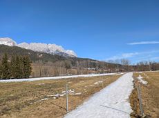
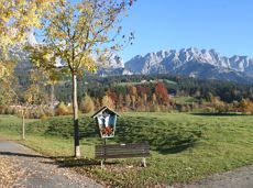
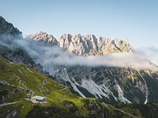
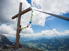
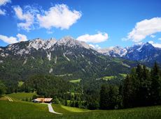
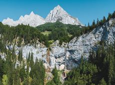
Rauher Kopf
Over hill and dale through idyllic nature up to the Rauhen Kopf.
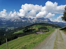
Astberg Bergstation
Astberg Bergstation
Wandelen
Normaal
4:45 u
13,1 km
620 Hoogtemeters
Over hill and dale through idyllic nature up to the Rauhen Kopf.
Astberg Bergstation
Astberg Bergstation
Wandelen
Normaal
4:45 u
13,1 km
620 Hoogtemeters
 aanbevolen
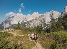
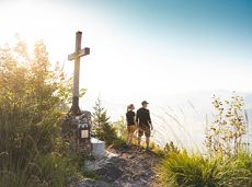
The viewpoint mountain of the locals, steep and fascinating.
Hiking starting point Alpenschlössl, Söll (762 m)
Hiking starting point Alpenschlössl, Söll (762 m)
Wandelen
Normaal
5:00 u
10,4 km
790 Hoogtemeters
 aanbevolen
Hiking starting point Tourist Info, Scheffau (737 m)
Hiking starting point Tourist Info, Scheffau (737 m)
Wandelen
Gemakkelijk
3:45 u
11,2 km
410 Hoogtemeters
 aanbevolen
Beautiful hike around the Hintersteiner See lake and to a small alpine village.
Hiking starting point Seestüberl, Scheffau (889 m)
Hiking starting point Seestüberl, Scheffau (889 m)
Wandelen
Gemakkelijk
3:45 u
12,3 km
350 Hoogtemeters
 aanbevolen
Hike along the sunny side along field paths and settlements from Scheffau to Ellmau..
Hiking starting point, Tourismus Info, Scheffau (737 m)
Bus stop Ellmau Bauhof/Dorf, Ellmau (800 m)
Wandelen
Gemakkelijk
1:30 u
5,7 km
100 Hoogtemeters
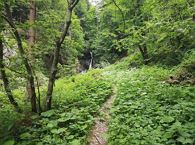
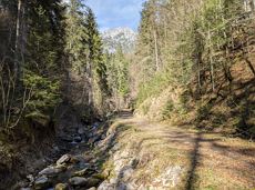
Short hike to the waterfall in the Breuergraben along the Schwarzache.
Brandstadlbahn valley station, Scheffau (681 m)
Brandstadlbahn valley station, Scheffau (681 m)
Wandelen
Gemakkelijk
1:00 u
3,0 km
150 Hoogtemeters
Comfortable round with a magnificent view of the Hohe Salve.
Mountain station gondola Hexenwasser, Söll (1,150 m)
Mountain station gondola Hexenwasser, Söll (1,150 m)
Wandelen
Gemakkelijk
0:35 u
1,8 km
50 Hoogtemeters
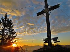
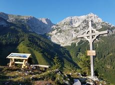
This pleasant circular walk takes you to Söll’s war memorial in a beautiful section of forest.
Hiking starting point Tourist Info, Söll (689 m)
Hiking starting point Tourist Info, Söll (689 m)
Wandelen
Gemakkelijk
0:30 u
2,1 km
10 Hoogtemeters
Enjoy unique panoramic views of the impressive mountains from the Biedringer Platte plateau.
Hiking starting point Tourist Info, Ellmau (800 m)
Hiking starting point Tourist Info, Ellmau (800 m)
Wandelen
Gemakkelijk
4:15 u
12,6 km
470 Hoogtemeters

Kaindlhütte - Bettlersteig - Anton-Karg-Haus - Hans-Berger-Haus - Stripsenjochhaus
Hintersteiner See, Scheffau (889 m)
Stripsenjochhaus, St. Johann in Tirol (1,577 m)
Wandelen
Normaal
5:00 u
9,3 km
840 Hoogtemeters
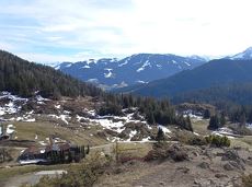
Family-friendly, leisurely circular hike around the Astberg mountain
Astberg mountain station, Going (1.251 m)
Astberg mountain station, Going (1.251 m)
Wandelen
Gemakkelijk
0:30 u
1,5 km
80 Hoogtemeters
This easy family hike takes you via the Bergdoktorhaus to the Berggasthof Hochschwendt mountain inn.
Wanderstartplatz Tourist Info, Ellmau (800m)
Wanderstartplatz Tourist Info, Ellmau (800m)
Wandelen
Gemakkelijk
2:45 u
8,7 km
270 Hoogtemeters
Off the beaten track up to the Köpfing farmhouse. “Der Bergdoktor” (The Mountain Doctor) is a famous German-Austrian TV series, which is produced in the Wilder Kaiser region.
Bergdoktor parking lot, Söll
Bergdoktor parking lot, Söll
Wandelen
Gemakkelijk
3:00 u
8,4 km
370 Hoogtemeters
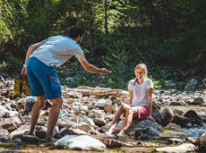
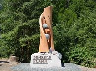
Refreshing walk through the Kneipp circuit and adventures in the Rehbachklamm gorge
Hiking starting point Tourist Info, Scheffau (738 m)
Hiking starting point Tourist Info, Scheffau (738 m)
Wandelen
Normaal
2:00 u
7,1 km
330 Hoogtemeters
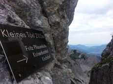
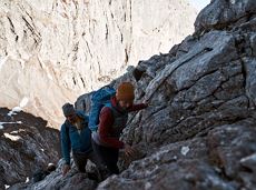
Demanding mountain tour to the Kleines Törl pass, the little "brother" of the Ellmauer Tor in the Ostkaiser.
Hiking starting point Tannbichl, Going (855 m)
Hiking starting point Tannbichl, Going (855 m)
Wandelen
Moeilijk
8:00 u
12,0 km
1260 Hoogtemeters

Challenging adventure hike to the Ellmauer Tor
Hiking starting point Wochenbrunner Alm, Ellmau (1,085 m)
Ellmauer Tor, Ellmau (2,001 m)
Wandelen
Normaal
5:00 u
7,7 km
900 Hoogtemeters
Gruttenhütte - Kaiser-Hochalm - Steiner-Hochalm - Jägersteig - Walleralm - Hochegg - Kaindlhütte
Gruttenhütte, Ellmau (1,620 m)
Hintersteiner See, Scheffau (889 m)
Wandelen
Normaal
5:30 u
13,5 km
560 Hoogtemeters
 aanbevolen
A relaxing hike towards the village center.
Hiking starting point Alpenschlössl, Söll (762 m)
Hiking starting point Alpenschlössl Söll (762 m)
Wandelen
Gemakkelijk
0:55 u
3,2 km
20 Hoogtemeters
Hike to the Gruttenhütte with great views to the Ellmauer Halt and the entire region.
Hiking starting point Tourist Info, Scheffau (738 m)
Gruttenhütte, Ellmau (1,620 m)
Wandelen
Normaal
6:30 u
16,4 km
990 Hoogtemeters

An adventure hike from Ellmau village centre to the Wochenbrunner Alm mountain hut from where you can enjoy stunning views and the Ellmau Stone Circle.
Hiking starting point Tourist Info, Ellmau (800 m)
Hiking starting point Tourist Info, Ellmau (800 m)
Wandelen
Gemakkelijk
4:30 u
13,5 km
530 Hoogtemeters
 aanbevolen
A tour of the main filming locations of the TV series “Der Bergdoktor” (The Mountain Doctor) in Ellmau and Going, with a refreshment stop at the inn used during filming
Hiking info point, Tourist Info Ellmau (800 m)
Hiking info point, Tourist Info Ellmau (800 m)
Wandelen
Gemakkelijk
3:15 u
11,4 km
180 Hoogtemeters
 aanbevolen
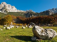
Head through well-shaded forests of green to reach the Ellmau Stone Circle. This is a place with a special energy, making it an inviting option for taking some time to relax.
Hiking starting point Wochenbrunner Alm, Ellmau (1,085 m)
Hiking starting point Wochenbrunner Alm, Ellmau (1,085 m)
Wandelen
Normaal
1:00 u
2,4 km
120 Hoogtemeters
Alpine pasture circular hiking route with a breathtaking view over Scheffau!
Hiking starting point Tourist Info, Scheffau (738 m)
Hiking starting point Tourist Info, Scheffau (738 m)
Wandelen
Normaal
5:15 u
12,9 km
800 Hoogtemeters
Themed hiking route with a trail full of natural experiences alongside the refreshing water.
Hiking starting point Tourist Info, Scheffau (738 m)
Hiking starting point Tourist Info, Scheffau (738 m)
Wandelen
Normaal
2:30 u
7,2 km
300 Hoogtemeters
 aanbevolen
Walking tour for refreshment and relaxation close to the village.
Hiking starting point Tourist Info, Scheffau (738 m)
Hiking starting point Tourist Info, Scheffau (738 m)
Wandelen
Gemakkelijk
0:45 u
2,3 km
70 Hoogtemeters
The panoramic Scheffauer is the last high peak in the west at 2,111 m above sea level.
Hiking starting point Bärnstatt, Scheffau (920 m)
Hiking starting point Bärnstatt, Scheffau (920 m)
Wandelen
Moeilijk
7:00 u
7,9 km
1180 Hoogtemeters

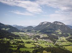
Scenic and varied circular hike.
Hiking starting point Going center (former tourist information Going) (764 m)
Hiking starting point Going center (former tourist information Going) (764 m)
Wandelen
Normaal
4:00 u
11,0 km
500 Hoogtemeters

Panoramic circular walk in the Wilder Kaiser leading to the highest mountain hut in the region.
Hiking starting point Tourist Info, Ellmau (800 m)
Hiking starting point Tourist Info, Ellmau (800 m)
Wandelen
Normaal
6:00 u
15,7 km
870 Hoogtemeters
Going, Hüttling – Graspoint-Niederalm – Obere Regalm – Brennender Palven – Gaudeamushütte – Klamml – Gruttenhütte
Hiking starting point Hüttling, Going (820 m)
Gaudeamushütte, Going (1,263 m) / Gruttenhütte, Ellmau (1,620 m)
Wandelen
Normaal
4:30 u
8,0 km
1120 Hoogtemeters

Wild and free - 5 days of hiking on old paths around the Wilder Kaiser The five-day hike from hut to hut is one of the most beautiful multi-day circular tours in Tirol. It takes mountain walkers along a route of around 58 kilometres, featuring ascents and descents with a difference in altitude of approximately 4,000 metres as they circle around the imposing Wilder Kaiser massif.
Hiking starting point Hüttling, Going (820 m)
Hiking starting point Hüttling, Going (820 m)
Wandelen
Normaal
27 u
57,7 km
4000 Hoogtemeters
Varied and challenging loop over the Scheffauer summit.
Kaindlhütte, Scheffau (1,293 m)
Scheffauer (2,111 m)
Wandelen
Moeilijk
8:30 u
13,0 km
1400 Hoogtemeters

Exciting round trip for adults and children through the Rehbach gorge.
Hiking starting point Tourist Info, Scheffau (738 m)
Hiking starting point Tourist Info, Scheffau (738 m)
Wandelen
Normaal
2:00 u
5,5 km
280 Hoogtemeters
A hike on varied paths around the Achleitberg.
Hiking starting point Tourist Info, Scheffau (738 m)
Hiking starting point Tourist Info, Scheffau (738 m)
Wandelen
Normaal
5:45 u
18,0 km
540 Hoogtemeters
Experience the picturesque beauty of a section of the Lengau Reflection Trail, which takes you along a steep route to the famous Söller Sunnseitweg.
Wanderstartplatz
Wanderstartplatz Alpenschlössl, Söll (762 m)
Wandelen
Normaal
2:15 u
5,7 km
340 Hoogtemeters
Gasteig – Wilder-Kaiser-Steig – Ursulablick – Gscheuerkopf – Graspoint-Hochalm – Graspoint-Niederalm – Going, Hüttling
Gasteig (750 m)
Hiking starting point Hüttling, Going (820 m)
Wandelen
Normaal
5:15 u
10,8 km
840 Hoogtemeters

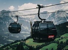
The highlight for everyone who loves hiking for pleasure - lush Alpine meadows, sparkling mountain lakes and delightful food in the Kitzbühel Alps. And the Bergbahnen Wilder Kaiser - Brixental summer cable cars make the ascent and descent easy.
Astberg, Going
Hochsöll
Wandelen
Gemakkelijk
6:45 u
20,0 km
720 Hoogtemeters
 aanbevolen
Explore the districts of Paisslberg and Ried on a leisurely hike for everyone.
Hiking starting point Alpenschlössl, Söll (762 m)
Hiking starting point Alpenschlössl, Söll (762 m)
Wandelen
Gemakkelijk
1:30 u
4,4 km
100 Hoogtemeters
Stripsenjochhaus - Griesner Alm - Griesenau
Stripsenjochhaus (1,577 m)
Griesenau, Kirchdorf (719 m)
Wandelen
Normaal
3:00 u
7,9 km
Turnoff to Granderalm – Schleier Waterfall – Going, Hüttling
First turnoff after the Granderalm
Hiking starting point Hüttling, Going (820 m)
Wandelen
Normaal
2:00 u
3,1 km
40 Hoogtemeters
Gaudeamushütte - Ellmauer Tor - Hintere Goinger Halt - Jubiläumssteig - Gruttenhütte
Gaudeamushütte, Going (1,263 m)
Gruttenhütte, Ellmau (1,620 m)
Wandelen
Moeilijk
5:30 u
5,9 km
1010 Hoogtemeters