


 Deutsch
 Nederlands
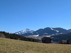
Sonnbichl circular route
 recommended
Ideal tour for starters and high temperatures.
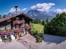
Hiking starting point Franzlhof, Söll (703 m)
Hiking starting point Franzlhof, Söll (703 m)
Hiking
Easy
0:45 h
2,4 km
50 Elevation gain
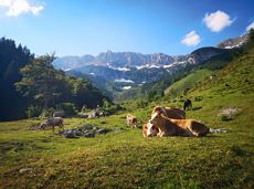
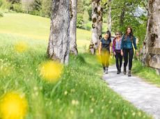
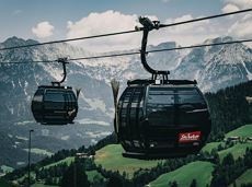
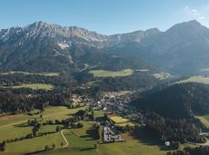
Especially in the valley and in the area of the Mountain Adventure Worlds, there are a large number of family-friendly and easy hiking trails, some of which are also very easy to navigate with prams. Many tours can be combined with lifts of the Wilder Kaiser-Brixental cable cars.
The tour recommendations listed here are based on the current weather conditions.
However, we would like to point out that the weather and therefore the conditions can change quickly and that every tour is undertaken at your own risk.
recommendedIdeal tour for starters and high temperatures.
Hiking starting point Franzlhof, Söll (703 m)
Hiking starting point Franzlhof, Söll (703 m)
Hiking
Easy
0:45 h
2,4 km
50 Elevation gain
 recommended
Short hike from Jägerwirt to the Kaiseralm with great mountain views.
Hiking starting point Jägerwirt, Scheffau (883 m)
Hiking starting point Jägerwirt, Scheffau (883 m)
Hiking
Easy
1:45 h
5,0 km
250 Elevation gain
 recommended
Walking tour for refreshment and relaxation close to the village.
Hiking starting point Tourist Info, Scheffau (738 m)
Hiking starting point Tourist Info, Scheffau (738 m)
Hiking
Easy
0:45 h
2,3 km
70 Elevation gain
 recommended
A relaxing hike towards the village center.
Hiking starting point Alpenschlössl, Söll (762 m)
Hiking starting point Alpenschlössl Söll (762 m)
Hiking
Easy
0:55 h
3,2 km
20 Elevation gain
 recommended
Explore small places with farms, forests and views of the valley between Scheffau and Ellmau.
Hiking starting point Tourist Info, Scheffau (737 m)
Hiking starting point Tourist Info, Scheffau (737 m)
Hiking
Easy
2:45 h
8,5 km
270 Elevation gain
 recommended
Looping the village of Söll, the sight seeing hike!
Hiking starting point Tourist Info, Söll (689 m)
Hiking starting point Tourist Info, Söll (689 m)
Hiking
Easy
1:00 h
3,7 km
50 Elevation gain
 recommended
Hike along the sunny side along field paths and settlements from Scheffau to Ellmau..
Hiking starting point, Tourismus Info, Scheffau (737 m)
Bus stop Ellmau Bauhof/Dorf, Ellmau (800 m)
Hiking
Easy
1:30 h
5,7 km
100 Elevation gain
 recommended
A beautiful easy hike at the foot of the Wilder Kaiser
Hiking starting point Tourist Info, Ellmau (800 m)
Hiking starting point Tourist Info, Ellmau (800 m)
Hiking
Easy
1:45 h
5,9 km
60 Elevation gain
 recommended
Leisurely hike through forest and across meadows to the sunny plateau of Going and back
Hiking starting point Going center (former tourist information Going) (764 m)
Hiking starting point Going center (former tourist information Going) (764 m)
Hiking
Easy
1:15 h
4,1 km
70 Elevation gain
 recommended
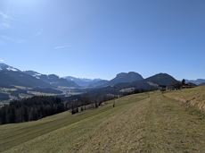
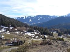
The Sunnseit circuit lives up to its name - this sunny circular hike leads through a varied landscape with fantastic views of Söll, the Wilder Kaiser, the Hohe Salve and the Pölven massif.
Hiking starting point Franzlhof, Söll (703 m)
Hiking starting point Franzlhof, Söll (703 m)
Hiking
Easy
2:15 h
7,3 km
180 Elevation gain
 recommended
Easy, flat circular path through the sunny village part 'Prama' for walkers families with pushchairs.
Hiking starting point Going center (former tourist information Going) (764 m)
Hiking starting point Going center (former tourist information Going) (764 m)
Hiking
Easy
1:00 h
3,9 km
30 Elevation gain
 recommended
A tour of the main filming locations of the TV series “Der Bergdoktor” (The Mountain Doctor) in Ellmau, with a refreshment stop at the inn used during filming
Hiking starting point Tourist Info, Ellmau (798 m)
Hiking starting point Tourist Info, Ellmau (798 m)
Hiking
Easy
2:15 h
7,5 km
200 Elevation gain
 recommended
A tour of the main filming locations of the TV series “Der Bergdoktor” (The Mountain Doctor) in Ellmau and Going, with a refreshment stop at the inn used during filming
Hiking info point, Tourist Info Ellmau (800 m)
Hiking info point, Tourist Info Ellmau (800 m)
Hiking
Easy
3:15 h
11,4 km
180 Elevation gain
 recommended
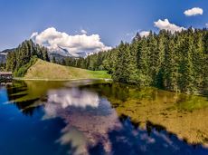
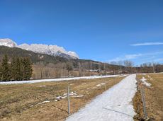
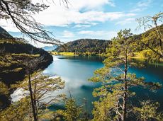
Crystal-clear mountain lake and magnificent views of the Wilder Kaiser’s western summits
Hintersteiner See, Scheffau (890 m)
Hintersteiner See, Scheffau (890 m)
Hiking
Easy
1:30 h
5,2 km
130 Elevation gain
 recommended
Explore the districts of Paisslberg and Ried on a leisurely hike for everyone.
Hiking starting point Alpenschlössl, Söll (762 m)
Hiking starting point Alpenschlössl, Söll (762 m)
Hiking
Easy
1:30 h
4,4 km
100 Elevation gain
 recommended
Short tour with varied paths and views
Hiking starting point Tourismus Info, Scheffau (737 m)
Hiking starting point Tourismus Info, Scheffau (737 m)
Hiking
Easy
2:00 h
5,8 km
230 Elevation gain
 recommended
Hiking starting point Tourist Info, Scheffau (737 m)
Hiking starting point Tourist Info, Scheffau (737 m)
Hiking
Easy
3:45 h
11,2 km
410 Elevation gain
 recommended
Nice circular hike through Going with visits to numerous chapels.
Hiking starting point Going center (former tourist information Going) (764 m)
Hiking starting point Going center (former tourist information Going) (764 m)
Hiking
Easy
2:45 h
9,3 km
210 Elevation gain
 recommended
Beautiful hike around the Hintersteiner See lake and to a small alpine village.
Hiking starting point Seestüberl, Scheffau (889 m)
Hiking starting point Seestüberl, Scheffau (889 m)
Hiking
Easy
3:45 h
12,3 km
350 Elevation gain
 recommended
Explore Going on the village circular tour and get to knowone or two hidden corners of our quiet, idyllic, artisan village with panoramic views of the Wilder Kaiser from a different angle.
Hiking starting point Going center (former tourist information Going) (764 m)
Hiking starting point Going center (former tourist information Going) (764 m)
Hiking
Easy
1:15 h
4,2 km
60 Elevation gain

From the Bergdoktorhaus to the Rübezahl-Alm mountain hut and the Carved Figures path to Ellmi’s Zauberwelt.
Hiking starting point Tourist Info, Ellmau (800 m)
Hiking starting point Tourist Info, Ellmau (800 m)
Hiking
Easy
5:30 h
15,8 km
730 Elevation gain

This short and easy valley circuit takes you around the village of Going am Wilden Kaiser and past the bathing lake, a delightful spot to cool off in fine weather.
Hiking starting point Going center (former tourist information Going) (764 m)
Hiking starting point Going center (former tourist information Going) (764 m)
Hiking
Easy
1:00 h
6,4 km
110 Elevation gain
Hiking trail no. 8 to the Hausberg via the Marienkapelle (St Mary’s Chapel)
Hiking starting point Tourist Information Office, Ellmau (798 m)
Brenner Alm, Ellmau (1,236 m)
Hiking
Easy
1:30 h
3,5 km
500 Elevation gain
Quietness, strength and with easy breathing steadily closer to the Wilder Kaiser. You can return on foot or by bus.
Hiking starting point Bergbahn, Söll (724 m)
Gasthof Bocking, Söll (665 m)
Hiking
Easy
1:45 h
5,5 km
100 Elevation gain
From Going to the Astberg with a short high-altitude loop & impressive panoramic view.
Hiking starting point Going center (former tourist information Going) (764 m)
Hiking starting point Going center (former tourist information Going) (764 m)
Hiking
Easy
3:30 h
8,6 km
560 Elevation gain
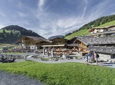
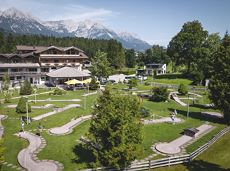
Experience culinaric highlights for the whole family.
Bergstation Rabennest (1.150 m)
Bergstation Rabennest (1.150 m)
Hiking
Easy
0:40 h
1,7 km
90 Elevation gain

Culinary tour on the Hohe Salve
Bergstation Rabennest (1.150 m)
Bergstation Rabennest (1.150 m)
Hiking
Easy
1:30 h
4,0 km
160 Elevation gain
Leisurely high-altitude hike on the mountain and by the Astbergsee lake - the Kaiser's mirror!
Blattlalm, Going (1,246 m)
Blattlalm, Going (1,246 m)
Hiking
Easy
0:40 h
1,7 km
80 Elevation gain
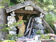
The Anna Grotto is hidden in the middle of a forest at the very foot of the Wilder Kaiser.
Wochenbrunner Alm, Ellmau (1,085 m)
Wochenbrunner Alm, Ellmau (1,085 m)
Hiking
Easy
0:20 h
0,7 km
50 Elevation gain

Hike to the Gaudeamushütte mountain hut by the Wilder Kaiser
Wochenbrunner Alm, Ellmau (1,085 m)
Gaudeamushütte, Going (1,263 m)
Hiking
Easy
0:35 h
1,3 km
175 Elevation gain

The best seat in the house for a view of the Wilder Kaiser!
Hiking starting point Going center (former tourist information Going) (764 m)
Hiking starting point Going center (former tourist information Going) (764 m)
Hiking
Easy
2:15 h
5,8 km
290 Elevation gain
Family-friendly, leisurely circular hike around the Astberg mountain
Astberg mountain station, Going (1.251 m)
Astberg mountain station, Going (1.251 m)
Hiking
Easy
0:30 h
1,5 km
80 Elevation gain
Comfortable round with a magnificent view of the Hohe Salve.
Mountain station gondola Hexenwasser, Söll (1,150 m)
Mountain station gondola Hexenwasser, Söll (1,150 m)
Hiking
Easy
0:35 h
1,8 km
50 Elevation gain
 Partially open
Hike from the centre of Ellmau, along trail no. 14, through the "Spatlahner gorge" up to the Wochenbrunner Alm.
Hiking starting point Tourist Info, Ellmau (800 m)
Hiking starting point Tourist Info, Ellmau (800 m)
Hiking
Easy
1:30 h
4,4 km
285 Elevation gain
This pleasant circular walk takes you to Söll’s war memorial in a beautiful section of forest.
Hiking starting point Tourist Info, Söll (689 m)
Hiking starting point Tourist Info, Söll (689 m)
Hiking
Easy
0:30 h
2,1 km
10 Elevation gain
Enjoy unique panoramic views of the impressive mountains from the Biedringer Platte plateau.
Hiking starting point Tourist Info, Ellmau (800 m)
Hiking starting point Tourist Info, Ellmau (800 m)
Hiking
Easy
4:15 h
12,6 km
470 Elevation gain
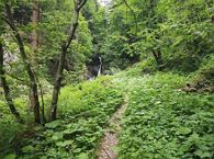
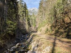
Short hike to the waterfall in the Breuergraben along the Schwarzache.
Brandstadlbahn valley station, Scheffau (681 m)
Brandstadlbahn valley station, Scheffau (681 m)
Hiking
Easy
1:00 h
3,0 km
150 Elevation gain
 Partially open
An adventure hike from Ellmau village centre to the Wochenbrunner Alm mountain hut from where you can enjoy stunning views and the Ellmau Stone Circle.
Hiking starting point Tourist Info, Ellmau (800 m)
Hiking starting point Tourist Info, Ellmau (800 m)
Hiking
Easy
4:30 h
13,5 km
530 Elevation gain
Round tour through Scheffau with panoramic views, refreshment by the stream and slowing down in the forest.
Hiking starting point Tourist Info, Scheffau (738 m)
Hiking starting point Tourist Info, Scheffau (738 m)
Hiking
Easy
1:15 h
4,3 km
90 Elevation gain

Hike to the Hexenwasser and get rewarded with a view.
Bergbahn valley station, Söll (724 m)
Bergbahn valley station, Söll (724 m)
Hiking
Easy
3:00 h
7,9 km
410 Elevation gain