


 Deutsch
 English
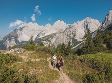
MTB Tour Obere Regalm Mountain Hut
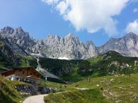
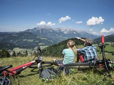
Bike tour to the idyllically situated Obere Regalm with a magnificent view.
Tourist Info, Going (764 m)
Tourist Info, Going (764 m)
Fietsen
Normaal
7,3 km
580 Hoogtemeters
De door u opgevraagde pagina is niet beschikbaar. U bent welkom om een nieuwe zoekopdracht op deze pagina te starten.
Bike tour to the idyllically situated Obere Regalm with a magnificent view.
Tourist Info, Going (764 m)
Tourist Info, Going (764 m)
Fietsen
Normaal
7,3 km
580 Hoogtemeters

Bike tour of medium difficulty between Hexenwasser theme park and Filzalmsee.
Tourist Information Office, Söll (703 m)
Filzalmsee
Fietsen
Normaal
8,8 km
680 Hoogtemeters
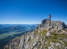
Very demanding round tour to the two eastern peaks in the Wilder Kaiser.
Hiking starting point Tannbichl, Going (857 m)
Hiking starting point Tannbichl, Going (857 m)
Wandelen
Moeilijk
9:00 u
13,0 km
1570 Hoogtemeters

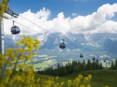
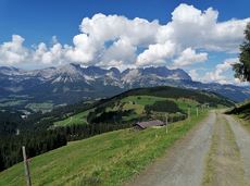
The highlight for everyone who loves hiking for pleasure - lush Alpine meadows, sparkling mountain lakes and delightful food in the Kitzbühel Alps. And the Bergbahnen Wilder Kaiser - Brixental summer cable cars make the ascent and descent easy.
Astberg, Going
Hochsöll
Wandelen
Gemakkelijk
6:45 u
20,0 km
720 Hoogtemeters

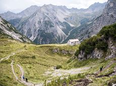
Wochenbrunner Alm – Gruttenhühtte
Hiking starting point Wochenbrunner Alm, Ellmau (1,085 m)
Gaudeamushütte, Going (1,263 m)
Wandelen
Normaal
1:45 u
2,6 km
530 Hoogtemeters
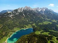
A nice run around the crystal-clear lake Hintersteiner See.
Starting point Seestüberl, Scheffau (822 m)
Starting point Seestüberl, Scheffau (882 m)
Hardlopen
Gemakkelijk
5,2 km
180 Hoogtemeters

The Kaiserkrone Trail is a trail running event with several competitions that lead around the Wilder Kaiser mountain massif. More about the event at: www.kaiserkrone.run
Start & Finish - village center of Scheffau (732 m), address: Dorf 45, 6351 Scheffau
Start & Finish - village center of Scheffau (732 m), address: Dorf 45, 6351 Scheffau
Hardlopen
Moeilijk
24,7 km
2690 Hoogtemeters
 Gedeeltelijk open
Pure adrenaline is the motto of the Pölven trail on the third day of the Tour de Tirol
Hiking starting point Tourist Info, Söll (689 m)
Hiking starting point Tourist Info, Söll (689 m)
Hardlopen
Normaal
22,8 km
1110 Hoogtemeters

Varied beginner trail round between the Kaiser towns of Ellmau and Going.
Wanderstartplatz Tourismus Info, Ellmau
Wanderstartplatz Tourismus Info, Ellmau
Hardlopen
Gemakkelijk
9,7 km
500 Hoogtemeters
Hikers exploring Tirol on foot will feel as free as a bird. The eagle walk is one of the 'Great Walks' of Tyrol chosen by a jury. They offer hikers the chance to get away from it all, discover the beauty of nature and experience a true adventure in the Alps.
St. Johann in Tirol
Arlbergpass
Wandelen
Moeilijk
413,0 km
31000 Hoogtemeters

An adventure hike from Ellmau village centre to the Wochenbrunner Alm mountain hut from where you can enjoy stunning views and the Ellmau Stone Circle.
Hiking starting point Tourist Info, Ellmau (800 m)
Hiking starting point Tourist Info, Ellmau (800 m)
Wandelen
Gemakkelijk
4:30 u
13,5 km
530 Hoogtemeters
 aanbevolen
Easy, flat circular path through the sunny village part 'Prama' for walkers families with pushchairs.
Hiking starting point Going center (former tourist information Going) (764 m)
Hiking starting point Going center (former tourist information Going) (764 m)
Wandelen
Gemakkelijk
1:00 u
3,9 km
30 Hoogtemeters
 Open
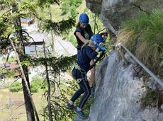
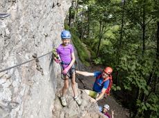
OpenVia ferrata

A circular route full of experiences that leads from the Seebachgraben gorge to the Wilder-Kaiser-Steig trail - discover one of the most beautiful parts of Scheffau!
Hiking starting point Tourist Info, Scheffau (738 m)
Hiking starting point Tourist Info, Scheffau (738 m)
Wandelen
Normaal
7:00 u
19,6 km
1140 Hoogtemeters
Hartkaiserbahn summit station - Ellmis Zauberwald - Tanzbodensee lake - Hartkaiserbahn summit station
Hartkaiser summit station, Ellmau (1,555 m)
Hartkaiser summit station, Ellmau (1,555 m)
Hardlopen
Gemakkelijk
3,4 km
120 Hoogtemeters
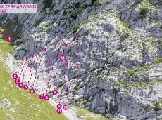
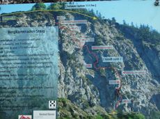
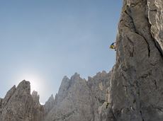
31 routes, including 14 multi-pitch.
Sportklimmen
By bike through the culinary region Wilder Kaiser.
anywhere along the tour
anywhere along the tour
Fietsen
Normaal
38,3 km
560 Hoogtemeters
Via ferrata
 aanbevolen
A beautiful easy hike at the foot of the Wilder Kaiser
Hiking starting point Tourist Info, Ellmau (800 m)
Hiking starting point Tourist Info, Ellmau (800 m)
Wandelen
Gemakkelijk
1:45 u
5,9 km
60 Hoogtemeters
Gentle walking or running course in Ellmau
Hiking starting point Tourist Info, Ellmau (800 m)
Hiking starting point Tourist Info, Ellmau (800 m)
Hardlopen
Gemakkelijk
0:20 u
3,0 km
54 Hoogtemeters
Shady hike with idyllic resting places and views from the Zillertaler Alpen to the Inn valley.
Hiking starting point Alpenschlössl, Söll (762 m)
Hiking starting point Alpenschlössl, Söll (762 m)
Wandelen
Gemakkelijk
3:30 u
9,5 km
480 Hoogtemeters
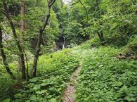
Short hike to the waterfall in the Breuergraben along the Schwarzache.
Brandstadlbahn valley station, Scheffau (681 m)
Brandstadlbahn valley station, Scheffau (681 m)
Wandelen
Gemakkelijk
1:00 u
3,0 km
150 Hoogtemeters

A demanding mountain tour with some ferrata passages up to the highest summit in the Wilder Kaiser (2,344 m).
Hiking starting point Wochenbrunner Alm, Ellmau (1,085 m)
Hiking starting point Wochenbrunner Alm, Ellmau (1,085 m)
Wandelen
Moeilijk
7:30 u
9,3 km
1250 Hoogtemeters

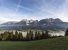
Explore the sunny foot of the Pölven mountain.
Hiking starting point Franzlhof, Söll (703 m)
Hiking starting point Franzlhof, Söll (703 m)
Wandelen
2:30 u
6,8 km
100 Hoogtemeters
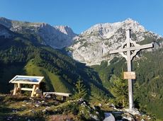
Going, Hüttling – Graspoint-Niederalm – Obere Regalm – Brennender Palven – Gaudeamushütte – Klamml – Gruttenhütte
Hiking starting point Hüttling, Going (820 m)
Gaudeamushütte, Going (1,263 m) / Gruttenhütte, Ellmau (1,620 m)
Wandelen
Normaal
4:30 u
8,0 km
1120 Hoogtemeters
Alpine pasture circular hiking route with a breathtaking view over Scheffau!
Hiking starting point Tourist Info, Scheffau (738 m)
Hiking starting point Tourist Info, Scheffau (738 m)
Wandelen
Normaal
5:15 u
12,9 km
800 Hoogtemeters
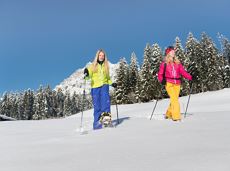
Easy snowshoe hike at the foot of the Wilder Kaiser.
Postbus stop Dorf/Bauhof, Ellmau
Postbus stop Dorf/Bauhof, Ellmau
Wandelen
0:40 u
1,3 km
10 Hoogtemeters
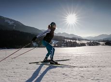
2 villages - you fancy quiete and a very rural athmosphere - Scheffau is the place to go, or, you opt for a great variety of gastronomy and restaurants - then Söll is good to go. No matter how, your decision is always superb. The ski hiking route is purely flat, which also means it's great for everybody.
restaurant Oberstegen, Söll
village, Scheffau
Langlaufen
Gemakkelijk
1,4 km
15 Hoogtemeters

Alpine klimroutes
 Open
OpenAttention! There is an increased risk of slipping on the ascents and descents due to snow fields! Walk at your own risk! The classic on the Steinplatte Waidring was rehabilitated in June 2023 and is a treat for via ferrata fans! The via ferrata "s'Schuastagangl" (C/D) offers wonderful panoramic views, crisp ascents and unforgettable mountain moments. The varied tour leads through steep rock faces and slippery passages up to the summit of the Waidringer Steinplatte (1,848m). Strength for steeper ascents and courage for ladder passages and the "Knieschloderer" variant with airy steps and a rope bridge are required!
Via ferrata
Alpine klimroutes
 Open
OpenVia ferrata
Over hill and dale through idyllic nature up to the Rauhen Kopf.
Astberg Bergstation
Astberg Bergstation
Wandelen
Normaal
4:45 u
13,1 km
620 Hoogtemeters
 aanbevolen
Walking tour for refreshment and relaxation close to the village.
Hiking starting point Tourist Info, Scheffau (738 m)
Hiking starting point Tourist Info, Scheffau (738 m)
Wandelen
Gemakkelijk
0:45 u
2,3 km
70 Hoogtemeters
A challenging circular mountainbike tour with plenty of welcoming refreshment stops.
Village Center, Söll (703 m)
Village Center, Söll (703 m)
Fietsen
Normaal
28,5 km
950 Hoogtemeters
A walk that lets you experience the Brandstadl mountain and leads you to Jochstubnsee lake.
Brandstadlbahn valley station, Scheffau (681 m)
Brandstadlbahn valley station, Scheffau (681 m)
Wandelen
Gemakkelijk
4:45 u
12,7 km
1130 Hoogtemeters
From Going to the Astberg with a short high-altitude loop & impressive panoramic view.
Hiking starting point Going center (former tourist information Going) (764 m)
Hiking starting point Going center (former tourist information Going) (764 m)
Wandelen
Gemakkelijk
3:30 u
8,6 km
560 Hoogtemeters
A gentle walk to ancient farmsteads with a refreshment stop in a welcoming inn.
Hiking starting point Tourist Info, Scheffau (738 m)
Hiking starting point Tourist Info, Scheffau (738 m)
Wandelen
1:30 u
3,8 km
80 Hoogtemeters
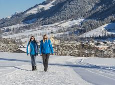
Enjoy unspoilt views of the Sölllandl region from snow-covered fields.
Hiking starting point Franzlhof, Söll (703 m)
Hiking starting point Franzlhof, Söll (703 m)
Wandelen
2:15 u
5,8 km
100 Hoogtemeters

From the flowery village to the water jewel of the Alps.
Hiking starting point Franzlhof, Söll (703 m)
Seestüberl restaurant, Hintersteiner See, Scheffau (890 m)
Wandelen
Normaal
3:15 u
9,5 km
460 Hoogtemeters