


 Deutsch
 English
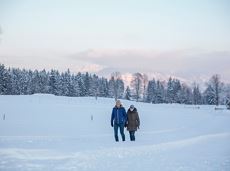
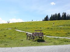
Moon toboggan run
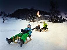
Exciting adventure stations for family tobogganing on the Hohe Salve.
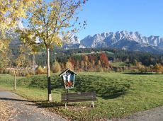
Cable car valley station, Söll (725 m)
Cable car valley station, Söll (725 m)
Rodelen
Gemakkelijk
4,0 km
De door u opgevraagde pagina is niet beschikbaar. U bent welkom om een nieuwe zoekopdracht op deze pagina te starten.
Exciting adventure stations for family tobogganing on the Hohe Salve.
Cable car valley station, Söll (725 m)
Cable car valley station, Söll (725 m)
Rodelen
Gemakkelijk
4,0 km
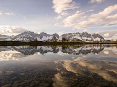
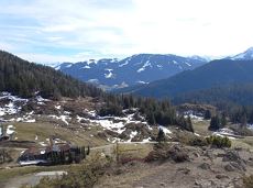
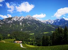
A beautiful tour up to the Astberg lake via the Hollenauer Kreuz with fantastic views
Astbergbahn valley station, Going (805 m)
Astbergsee, Going (1.251m)
Wandelen
Gemakkelijk
3,0 km
465 Hoogtemeters
Stripsenjochhaus – Stripsenkopf – Feldberg – Scheibenbichlalmen – Griesenau – Gasteig
Stripsenjochhaus, St. Johann in Tirol (1,577 m)
Gasteig (750 m)
Wandelen
Normaal
6:30 u
16,1 km
640 Hoogtemeters
 Open
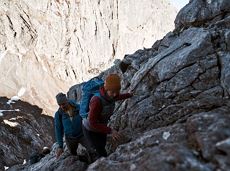
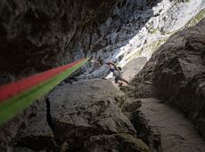
OpenVia ferrata
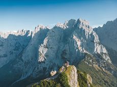
Enjoy unique panoramic views of the impressive mountains from the Biedringer Platte plateau.
Hiking starting point Tourist Info, Ellmau (800 m)
Hiking starting point Tourist Info, Ellmau (800 m)
Wandelen
Gemakkelijk
4:15 u
12,6 km
470 Hoogtemeters
Postkarten circuit Ellmau Ellmau hiking info point – Kapellenpark – Marienkapelle – Ellmau Parish Church
Hiking starting point Tourist Info, Ellmau (800 m)
Hiking starting point Tourist Info, Ellmau (800 m)
Wandelen
Gemakkelijk
0:25 u
1,3 km
40 Hoogtemeters

Bike tour of medium difficulty between Hexenwasser theme park and Filzalmsee.
Tourist Information Office, Söll (703 m)
Filzalmsee
Fietsen
Normaal
8,8 km
680 Hoogtemeters
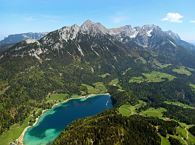
The best hiking routes from village centre Scheffau to Lake Hinterstein.
Community Hall, Scheffau (740 m)
Hintersteiner See, Scheffau (890 m)
Wandelen
Normaal
1:30 u
4,5 km
240 Hoogtemeters
From Going to the Astberg with a short high-altitude loop & impressive panoramic view.
Hiking starting point Going center (former tourist information Going) (764 m)
Hiking starting point Going center (former tourist information Going) (764 m)
Wandelen
Gemakkelijk
3:30 u
8,6 km
560 Hoogtemeters
A challenging circular mountainbike tour with plenty of welcoming refreshment stops.
Village Center, Söll (703 m)
Village Center, Söll (703 m)
Fietsen
Normaal
28,5 km
950 Hoogtemeters
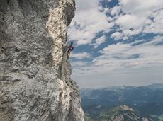
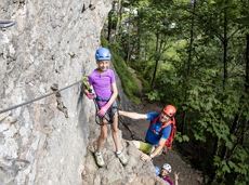
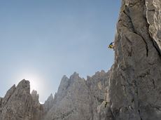
A classic amongst the via ferratas on the Wilder Kaiser massif – ideal as a 2-day tour.
Via ferrata
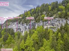
More than 190 sport climbing routes, difficulty levels 3 to 9a+
Sportklimmen
Round tour through Scheffau with panoramic views, refreshment by the stream and slowing down in the forest.
Hiking starting point Tourist Info, Scheffau (738 m)
Hiking starting point Tourist Info, Scheffau (738 m)
Wandelen
Gemakkelijk
1:15 u
4,3 km
90 Hoogtemeters
 aanbevolen
Beautiful hike around the Hintersteiner See lake and to a small alpine village.
Hiking starting point Seestüberl, Scheffau (889 m)
Hiking starting point Seestüberl, Scheffau (889 m)
Wandelen
Gemakkelijk
3:45 u
12,3 km
350 Hoogtemeters
The panoramic Scheffauer is the last high peak in the west at 2,111 m above sea level.
Hiking starting point Bärnstatt, Scheffau (920 m)
Hiking starting point Bärnstatt, Scheffau (920 m)
Wandelen
Moeilijk
7:00 u
7,9 km
1180 Hoogtemeters
 aanbevolen
The Sunnseit circuit lives up to its name - this sunny circular hike leads through a varied landscape with fantastic views of Söll, the Wilder Kaiser, the Hohe Salve and the Pölven massif.
Hiking starting point Franzlhof, Söll (703 m)
Hiking starting point Franzlhof, Söll (703 m)
Wandelen
Gemakkelijk
2:15 u
7,3 km
180 Hoogtemeters
 Gesloten
Via ferrata

A run during which you can enjoy peace and quiet in the great outdoors.
Starting point Scheffau Tourist Information Office (752 m)
Starting point Scheffau Tourist Information Office (752 m)
Hardlopen
Normaal
6,1 km
260 Hoogtemeters
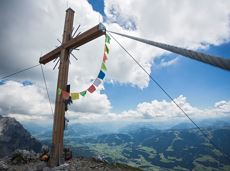
On the north side up to the Ellmauer Halt summit 2,344 m.
Via ferrata
Peace and strength, slow down and take a deep breath.
Ahornsee car park, Söll (693 m)
Ahornsee car park, Söll (693 m)
Wandelen
Gemakkelijk
4:45 u
12,0 km
220 Hoogtemeters

By bike through the culinary region Wilder Kaiser.
anywhere along the tour
anywhere along the tour
Fietsen
Normaal
38,3 km
560 Hoogtemeters
Gaudeamushütte - Ellmauer Tor - Hintere Goinger Halt - Jubiläumssteig - Gruttenhütte
Gaudeamushütte, Going (1,263 m)
Gruttenhütte, Ellmau (1,620 m)
Wandelen
Moeilijk
5:30 u
5,9 km
1010 Hoogtemeters
 aanbevolen
A beautiful easy hike at the foot of the Wilder Kaiser
Hiking starting point Tourist Info, Ellmau (800 m)
Hiking starting point Tourist Info, Ellmau (800 m)
Wandelen
Gemakkelijk
1:45 u
5,9 km
60 Hoogtemeters
 Gedeeltelijk open
An adventure hike from Ellmau village centre to the Wochenbrunner Alm mountain hut from where you can enjoy stunning views and the Ellmau Stone Circle.
Hiking starting point Tourist Info, Ellmau (800 m)
Hiking starting point Tourist Info, Ellmau (800 m)
Wandelen
Gemakkelijk
4:30 u
13,5 km
530 Hoogtemeters

A circular route full of experiences that leads from the Seebachgraben gorge to the Wilder-Kaiser-Steig trail - discover one of the most beautiful parts of Scheffau!
Hiking starting point Tourist Info, Scheffau (738 m)
Hiking starting point Tourist Info, Scheffau (738 m)
Wandelen
Normaal
7:00 u
19,6 km
1140 Hoogtemeters
Following the Stampfangerbach stream on the way to Filzalm lake
Hiking starting point Bergbahn, Söll (725 m)
Hiking starting point Bergbahn, Söll (725 m)
Wandelen
Normaal
3:15 u
9,0 km
620 Hoogtemeters

Ellmau village park - Hartkaiserbahn valley station - Bergschenke - Rübezahlalm - Jägerhütte - Hartkaiser summit station
Hiking starting point Tourist Info, Ellmau (800 m)
Hartkaiser summit station, Ellmau (1,555 m)
Hardlopen
Normaal
8,2 km
720 Hoogtemeters

Varied beginner trail round between the Kaiser towns of Ellmau and Going.
Wanderstartplatz Tourismus Info, Ellmau
Wanderstartplatz Tourismus Info, Ellmau
Hardlopen
Gemakkelijk
9,7 km
500 Hoogtemeters
Circular cycling route for leisure bikers between the four villages of the Kaiser region.
anywhere along the tour
anywhere along the tour
Fietsen
Normaal
38,5 km
550 Hoogtemeters

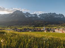
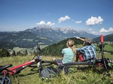
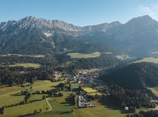
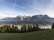
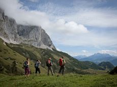
The highlight for everyone who loves hiking for pleasure - lush Alpine meadows, sparkling mountain lakes and delightful food in the Kitzbühel Alps. And the Bergbahnen Wilder Kaiser - Brixental summer cable cars make the ascent and descent easy.
Astberg, Going
Hochsöll
Wandelen
Gemakkelijk
6:45 u
20,0 km
720 Hoogtemeters
Alpine klimroutes
Sturdy boots will help keep your ankles and feet happy on this hike, full of the best things Tirol has to offer: well-maintained trails, wildflowers galore and waterfalls beckon the adventurous hiker ready for a strenuous climb with breathtaking views of lofty Wilder Kaiser Mountain Range as your reward. The nature reserve’s landscape will win you over with its diverse beauty. The pasture regions are covered with soft grassy meadows, and hikers are greeted by lofty Wilder Kaiser Mountain Range with rugged Maukspitze, Ackerlspitze, Regalpspitze and Törlspitze Peaks, all “Two-Thousanders” that average 2,000 metres altitude. Trailhead is Rummlerhof Inn, northwest of the village centre of St. Johann. After a successful first segment, why not take a rest at Gaudeamus Hut, raise your glass and sing: “Gaudeamus igitur – Let us be happy!” For many hikers this is far enough, contentment has already set in. Adventurous souls continue on the trail that works its way up across Klamml Gorge to Grutten Hut, which entails another 400 metres of climbing.
Rummlerhof, St.Johann in Tirol
Gaudeamushütte
Wandelen
Normaal
5:00 u
13,0 km
1060 Hoogtemeters
Through the winter forest to the wildlife park at the Wochenbrunner Alm.
Hiking starting point Tourist Info, Ellmau (800 m)
Hiking starting point Tourist Info, Ellmau (800 m)
Wandelen
Normaal
3:30 u
9,0 km
300 Hoogtemeters
There are 3 steep rises which are moderable with e-bikes.
Cable car valley station, Söll (725 m)
Au Hoch-Alm, Söll (1.600 m)
Fietsen
Normaal
8,9 km
860 Hoogtemeters
Leisurely high-altitude hike on the mountain and by the Astbergsee lake - the Kaiser's mirror!
Blattlalm, Going (1,246 m)
Blattlalm, Going (1,246 m)
Wandelen
Gemakkelijk
0:40 u
1,7 km
80 Hoogtemeters
The heart of the tour is the deep, wonderful-to-climb chimney, which lends the tour an Alpine character.
Alpine klimroutes
 aanbevolen
Leisurely hike through forest and across meadows to the sunny plateau of Going and back
Hiking starting point Going center (former tourist information Going) (764 m)
Hiking starting point Going center (former tourist information Going) (764 m)
Wandelen
Gemakkelijk
1:15 u
4,1 km
70 Hoogtemeters

Approaching from the north, this trail leads through the Steinerne Rinne to the majestic Ellmauer Tor.
Griesner Alm, 988 m
Wochenbrunner Alm, Ellmau (1,085 m)
Wandelen
Moeilijk
5:45 u
8,1 km
1060 Hoogtemeters
A hike on varied paths around the Achleitberg.
Hiking starting point Tourist Info, Scheffau (738 m)
Hiking starting point Tourist Info, Scheffau (738 m)
Wandelen
Normaal
5:45 u
18,0 km
540 Hoogtemeters

Hike to the Hexenwasser and get rewarded with a view.
Bergbahn valley station, Söll (724 m)
Bergbahn valley station, Söll (724 m)
Wandelen
Gemakkelijk
3:00 u
7,9 km
410 Hoogtemeters