


 Deutsch
 English
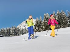
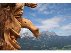
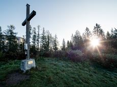
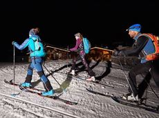
snowshoe hiking "Bergdoktor"
Explore the popular path past the TV backdrop on snowshoes.
Cable car valley station, Söll (725 m)
Cable car valley station, Söll (725 m)
Wandelen
4:45 u
7,0 km
350 Hoogtemeters
De door u opgevraagde pagina is niet beschikbaar. U bent welkom om een nieuwe zoekopdracht op deze pagina te starten.
Explore the popular path past the TV backdrop on snowshoes.
Cable car valley station, Söll (725 m)
Cable car valley station, Söll (725 m)
Wandelen
4:45 u
7,0 km
350 Hoogtemeters
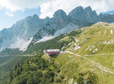
Gaudeamushütte - Ellmauer Tor - Klammlweg - Gruttenhütte
Gaudeamushütte, Going (1,263 m)
Gruttenhütte, Ellmau (1,620 m)
Wandelen
Normaal
4:45 u
5,9 km
990 Hoogtemeters
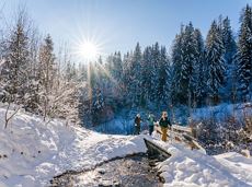
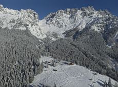
Savour the wonder of the winter landscape – experience the winter magic for yourself by crunching through the pristine snow with your snowshoes. Enjoy unique impressions and experiences as you explore the white winter splendour and take in the spectacular view over the surrounding mountain scenery.
Church square, Going (769 m)
Church square, Going (769 m)
Wandelen
1:30 u
2,9 km
110 Hoogtemeters
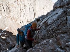
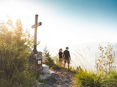
Very demanding round tour to the two eastern peaks in the Wilder Kaiser.
Hiking starting point Tannbichl, Going (857 m)
Hiking starting point Tannbichl, Going (857 m)
Wandelen
Moeilijk
9:00 u
13,0 km
1570 Hoogtemeters
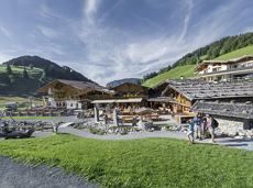
Experience culinaric highlights for the whole family.
Bergstation Rabennest (1.150 m)
Bergstation Rabennest (1.150 m)
Wandelen
Gemakkelijk
0:40 u
1,7 km
90 Hoogtemeters
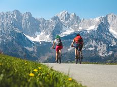
Circular cycling route for leisure bikers between the four villages of the Kaiser region.
anywhere along the tour
anywhere along the tour
Fietsen
Normaal
38,5 km
550 Hoogtemeters
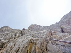
Alpine klimroutes
 Gedeeltelijk open
Pleasant circular hiking trail through forests and meadows to the romantically situated moor lake.
Hiking starting point Franzlhof, Söll (703 m)
Hiking starting point Franzlhof, Söll (703 m)
Wandelen
Normaal
2:00 u
5,7 km
240 Hoogtemeters
Easy snowshoe hike at the foot of the Wilder Kaiser.
Postbus stop Dorf/Bauhof, Ellmau
Postbus stop Dorf/Bauhof, Ellmau
Wandelen
0:40 u
1,3 km
10 Hoogtemeters
Family hike on Austria’s longest sculpture trail
Hartkaiser summit station, Ellmau (1,555 m)
Rübezahl-Alm, Ellmau (1,174 m)
Wandelen
Normaal
1:00 u
2,5 km
50 Hoogtemeters

Alpine klimroutes
 aanbevolen
Head through well-shaded forests of green to reach the Ellmau Stone Circle. This is a place with a special energy, making it an inviting option for taking some time to relax.
Hiking starting point Wochenbrunner Alm, Ellmau (1,085 m)
Hiking starting point Wochenbrunner Alm, Ellmau (1,085 m)
Wandelen
Normaal
1:00 u
2,4 km
120 Hoogtemeters
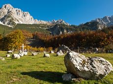
This pleasant circular walk takes you to Söll’s war memorial in a beautiful section of forest.
Hiking starting point Tourist Info, Söll (689 m)
Hiking starting point Tourist Info, Söll (689 m)
Wandelen
Gemakkelijk
0:30 u
2,1 km
10 Hoogtemeters
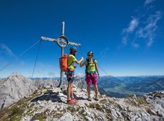
Two very demanding, fantastic lookout peaks on the Wilder Kaiser, which are not to be underestimated.
Hiking starting point Wegscheid, Scheffau (883 m)
Hiking starting point Wegscheid, Scheffau (883 m)
Wandelen
Moeilijk
9:00 u
11,0 km
1440 Hoogtemeters
Shady hike with idyllic resting places and views from the Zillertaler Alpen to the Inn valley.
Hiking starting point Alpenschlössl, Söll (762 m)
Hiking starting point Alpenschlössl, Söll (762 m)
Wandelen
Gemakkelijk
3:30 u
9,5 km
480 Hoogtemeters
Enjoy snowy forests and nature in winter.
Hiking starting point Tourist Info, Scheffau (738 m)
Hiking starting point Tourist Info, Scheffau (738 m)
Wandelen
1:45 u
3,8 km
170 Hoogtemeters
Up for a wild witch’s ride? Day and night: off you go!
Cable car valley station, Söll (725 m)
Cable car valley station, Söll (725 m)
Rodelen
Normaal
3,0 km
Picturesque circular hiking trail on the sunny side of Going in unspoilt nature - over snow fields with fantastic views of Going aht the Wilder Kaiser.
Hiking starting point Going center (former tourist information Going) (764 m)
Hiking starting point Going center (former tourist information Going) (764 m)
Wandelen
1:45 u
4,8 km
80 Hoogtemeters
A unique hike to the highest mountain hut in the Wilder Kaiser region featuring a panoramic view.
Hiking starting point Going center (former tourist information Going) (764 m)
Hiking starting point Going center (former tourist information Going) (764 m)
Wandelen
Normaal
5:45 u
14,2 km
860 Hoogtemeters
Alpine klimroutes
 aanbevolen
Explore small places with farms, forests and views of the valley between Scheffau and Ellmau.
Hiking starting point Tourist Info, Scheffau (737 m)
Hiking starting point Tourist Info, Scheffau (737 m)
Wandelen
Gemakkelijk
2:45 u
8,5 km
270 Hoogtemeters
Kufstein – Brentenjoch – Kaindlhütte
Kaiserlift summit station, Kufstein (1,255 m)
Kaindlhütte, Scheffau (1,293 m)
Wandelen
Gemakkelijk
1:30 u
2,9 km
220 Hoogtemeters
Moorland hike suitable for children. Discover the special inhabitants of the moor with Törfchen, the moor elf.
Römerhof, St. Johann (769 m)
Römerhof, St. Johann (769 m)
Wandelen
Gemakkelijk
1:30 u
4,3 km
100 Hoogtemeters
Experience the picturesque beauty of a section of the Lengau Reflection Trail, which takes you along a steep route to the famous Söller Sunnseitweg.
Wanderstartplatz
Wanderstartplatz Alpenschlössl, Söll (762 m)
Wandelen
Normaal
2:15 u
5,7 km
340 Hoogtemeters
Through the winter forest to the wildlife park at the Wochenbrunner Alm.
Hiking starting point Tourist Info, Ellmau (800 m)
Hiking starting point Tourist Info, Ellmau (800 m)
Wandelen
3:30 u
9,0 km
300 Hoogtemeters
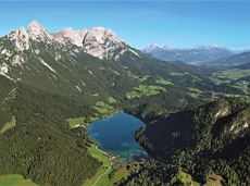
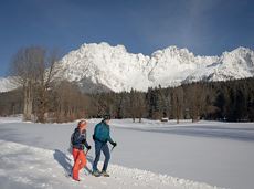
A picturesque mountain hike that leads from the turquoise waters of the most beautiful mountain lake in Tirol up to the rustic Alpine village.
Hiking starting point Seestüberl, Scheffau (890 m)
Hiking starting point Seestüberl, Scheffau (890 m)
Wandelen
Normaal
3:15 u
9,3 km
360 Hoogtemeters

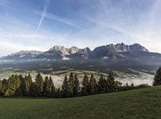
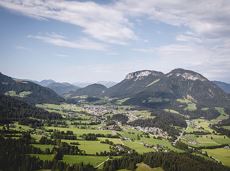
The highlight for everyone who loves hiking for pleasure - lush Alpine meadows, sparkling mountain lakes and delightful food in the Kitzbühel Alps. And the Bergbahnen Wilder Kaiser - Brixental summer cable cars make the ascent and descent easy.
Astberg, Going
Hochsöll
Wandelen
Gemakkelijk
6:45 u
20,0 km
720 Hoogtemeters
Gaudeamushütte - Ellmauer Tor - Hintere Goinger Halt - Jubiläumssteig - Gruttenhütte
Gaudeamushütte, Going (1,263 m)
Gruttenhütte, Ellmau (1,620 m)
Wandelen
Moeilijk
5:30 u
5,9 km
1010 Hoogtemeters

Winter hike with picturesque views of the Wilder Kaiser to the 'Wolfsegg' plateau
Hiking starting point Going center (former tourist information Going) (764 m)
Hiking starting point Going center (former tourist information Going) (764 m)
Wandelen
1:30 u
4,0 km
65 Hoogtemeters
A moderately challenging panoramic circuit around the Astberg mountain.
Tourist Info, Going (764 m)
Tourist Info, Going (764 m)
Fietsen
Normaal
15,3 km
480 Hoogtemeters
Hiking trail no. 8 to the Hausberg via the Marienkapelle (St Mary’s Chapel).
Hiking starting point Tourist Information Office, Ellmau (798 m)
Brenner Alm, Ellmau (1,236 m)
Wandelen
Gemakkelijk
3:00 u
7,5 km
440 Hoogtemeters
 aanbevolen
A tour of the main filming locations of the TV series “Der Bergdoktor” (The Mountain Doctor) in Ellmau and Going, with a refreshment stop at the inn used during filming
Hiking info point, Tourist Info Ellmau (800 m)
Hiking info point, Tourist Info Ellmau (800 m)
Wandelen
Gemakkelijk
3:15 u
11,4 km
180 Hoogtemeters

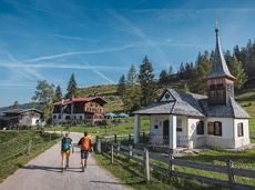
Past inn, farm and chapel in the Kaiser countryside.
Hiking starting point Going Center (former Tourist informatin Going)
Hiking starting point Going Center (former Tourist informatin Going)
Langlaufen
Gemakkelijk
1,2 km
10 Hoogtemeters

Alpine klimroutes

Kaindlhütte - Bettlersteig - Anton-Karg-Haus - Hans-Berger-Haus - Stripsenjochhaus
Hintersteiner See, Scheffau (889 m)
Stripsenjochhaus, St. Johann in Tirol (1,577 m)
Wandelen
Normaal
5:00 u
9,3 km
840 Hoogtemeters
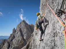
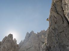
This well-secured sport climbing route features interesting lines in prime rock.
Alpine klimroutes
 Gesloten
Moderately difficult ascent route along the ski route 80c/d to the Hartkaiser.
Hartkaiserbahn valley station, Ellmau (824 m)
Hartkaiserbahn mountain station, Ellmau (1.524 m)
Skitocht
Normaal
2:30 u
4,2 km
700 Hoogtemeters

An adventure hike from Ellmau village centre to the Wochenbrunner Alm mountain hut from where you can enjoy stunning views and the Ellmau Stone Circle.
Hiking starting point Tourist Info, Ellmau (800 m)
Hiking starting point Tourist Info, Ellmau (800 m)
Wandelen
Gemakkelijk
4:30 u
13,5 km
530 Hoogtemeters

Soccer field, Söll (687 m)
Soccer field, Söll (687 m)
Hardlopen
Gemakkelijk
2,5 km
30 Hoogtemeters
Gasteig – Wilder-Kaiser-Steig – Ursulablick – Gscheuerkopf – Graspoint-Hochalm – Graspoint-Niederalm – Going, Hüttling
Gasteig (750 m)
Hiking starting point Hüttling, Going (820 m)
Wandelen
Normaal
5:15 u
10,8 km
840 Hoogtemeters