


 Deutsch
 English
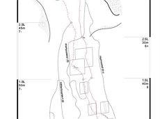
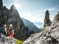
Via ferrata Marokka Fieberbrunn
Gesloten
Via ferrata
De door u opgevraagde pagina is niet beschikbaar. U bent welkom om een nieuwe zoekopdracht op deze pagina te starten.
Via ferrata
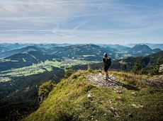
Short beginners’ trail - central, easy and crisp!
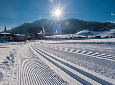
Langlaufen
Gemakkelijk
1,0 km

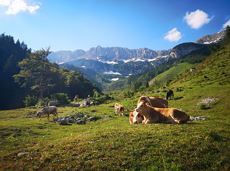
A tour for experienced bikers in the Kaiser's Alpine pasture area.
Community Hall, Scheffau (740 m)
Community Hall, Scheffau (740 m)
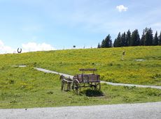
Fietsen
Moeilijk
21,3 km
690 Hoogtemeters
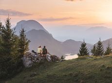
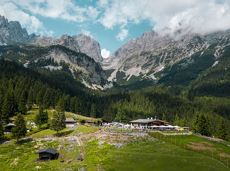
Leisurely high-altitude hike on the mountain and by the Astbergsee lake - the Kaiser's mirror!
Blattlalm, Going (1,246 m)
Blattlalm, Going (1,246 m)
Wandelen
Gemakkelijk
0:40 u
1,7 km
80 Hoogtemeters
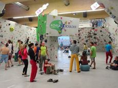
The largest bouldering hall in the Tirolean Unterland region.
Kletterhalle
Up to the best box seat: the Wilder Kaiser within reach!
Hiking starting point Going center (former tourist information Going) (764 m)
Hiking starting point Going center (former tourist information Going) (764 m)
Wandelen
Normaal
4:30 u
10,7 km
360 Hoogtemeters
Alpine klimroutes
Extended walk through the landscape of Scheffau and Söll
Hiking starting point Tourist Info, Scheffau (738 m)
Hiking starting point Tourist Info, Scheffau (738 m)
Wandelen
Gemakkelijk
3:30 u
8,8 km
210 Hoogtemeters

Explore Going on the village circular tour and get to knowone or two hidden corners of our quiet, idyllic, artisan village with panoramic views of the Wilder Kaiser from a different angle.
Hiking starting point Going center (former tourist information Going) (764 m)
Hiking starting point Going center (former tourist information Going) (764 m)
Wandelen
Gemakkelijk
1:15 u
4,2 km
60 Hoogtemeters
Atmospheric winter hike right into the Wilder Kaiser.
Bathing lake, Going (742 m)
Graspoint-Niederalm, Going (981 m)
Wandelen
Gemakkelijk
2:30 u
5,7 km
250 Hoogtemeters
From Going to the Astberg with a short high-altitude loop & impressive panoramic view.
Hiking starting point Going center (former tourist information Going) (764 m)
Hiking starting point Going center (former tourist information Going) (764 m)
Wandelen
Gemakkelijk
3:30 u
8,6 km
560 Hoogtemeters
This pleasant circular walk takes you to Söll’s war memorial in a beautiful section of forest.
Hiking starting point Tourist Info, Söll (689 m)
Hiking starting point Tourist Info, Söll (689 m)
Wandelen
Gemakkelijk
0:30 u
2,1 km
10 Hoogtemeters
Moorland hike suitable for children. Discover the special inhabitants of the moor with Törfchen, the moor elf.
Römerhof, St. Johann (769 m)
Römerhof, St. Johann (769 m)
Wandelen
Gemakkelijk
1:30 u
4,3 km
100 Hoogtemeters
This easy family hike takes you via the Bergdoktorhaus to the Berggasthof Hochschwendt mountain inn.
Wanderstartplatz Tourist Info, Ellmau (800m)
Wanderstartplatz Tourist Info, Ellmau (800m)
Wandelen
Gemakkelijk
2:45 u
8,7 km
270 Hoogtemeters
Comfortable round with a magnificent view of the Hohe Salve.
Mountain station gondola Hexenwasser, Söll (1,150 m)
Mountain station gondola Hexenwasser, Söll (1,150 m)
Wandelen
Gemakkelijk
0:35 u
1,8 km
50 Hoogtemeters
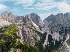
Experience impressive low and panoramic views in the unique rocky scenery of the legendary "Wild Castle", as this area is known according to legend thanks to its many turrets, peaks, hollows and balconies.
Wochenbrunner Alm, Ellmau (1.085 m)
Wochenbrunner Alm, Ellmau (1.085 m)
Wandelen
Moeilijk
3:45 u
6,3 km
630 Hoogtemeters
Short hike from Jägerwirt to the Kaiseralm with great mountain views.
Hiking starting point Jägerwirt, Scheffau (883 m)
Hiking starting point Jägerwirt, Scheffau (883 m)
Wandelen
Gemakkelijk
1:45 u
5,0 km
250 Hoogtemeters
Gruttenhütte - Kaiser-Hochalm - Steiner-Hochalm - Hinterschießling Alm - Rehbachklamm - Scheffau, Dorf
Gruttenhütte, Ellmau (1,620 m)
Scheffau village (889 m)
Wandelen
Normaal
4:30 u
11,4 km
190 Hoogtemeters

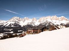
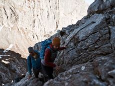
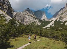
A demanding mountain tour with some ferrata passages up to the highest summit in the Wilder Kaiser (2,344 m).
Hiking starting point Wochenbrunner Alm, Ellmau (1,085 m)
Hiking starting point Wochenbrunner Alm, Ellmau (1,085 m)
Wandelen
Moeilijk
7:30 u
9,3 km
1250 Hoogtemeters
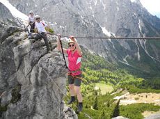
This 3-part Via Ferrata features a rope bridge and an extremely difficult exit option.
Via ferrata
Wochenbrunner Alm – Gruttenhühtte
Hiking starting point Wochenbrunner Alm, Ellmau (1,085 m)
Gaudeamushütte, Going (1,263 m)
Wandelen
Normaal
1:45 u
2,6 km
530 Hoogtemeters
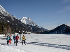
Beautiful circular walk around the frozen Lake Hinterstein.
Hiking starting point Seestüberl, Scheffau (890 m)
Hiking starting point Seestüberl, Scheffau (890 m)
Wandelen
Gemakkelijk
2:00 u
5,7 km
70 Hoogtemeters
The Wilder Kaiser always in view.
Ahornsee car park, Söll (693 m)
Hiking starting point Bocking, Söll (670 m)
Wandelen
Gemakkelijk
3:30 u
6,0 km
130 Hoogtemeters

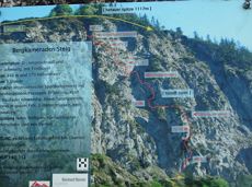
Via ferrata

Fork 823/826 – via waterfall – Veitskirche – Steiner-Hochalm
Fork on the Wilder-Kaiser-Steig 823/826 (1,405 m)
Steiner-Hochalm, Scheffau (1,257 m)
Wandelen
Normaal
2:30 u
3,8 km
360 Hoogtemeters
A short winter walk on Hartkaiser hrough Ellmi's magical world.
Hiking starting point Tourist Info, Ellmau (800 m)
Hiking starting point Tourist Info, Ellmau (800 m)
Wandelen
Gemakkelijk
0:30 u
1,0 km
25 Hoogtemeters

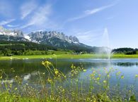
From the flowery village to the water jewel of the Alps.
Hiking starting point Franzlhof, Söll (703 m)
Seestüberl restaurant, Hintersteiner See, Scheffau (890 m)
Wandelen
Normaal
3:15 u
9,5 km
460 Hoogtemeters
Wilder Kaiser hike to a series of special locations. Featuring the natural spectacle of the Schleier Waterfall and a view of the Gaudeamushütte mountain hut.
Hüttling, Going (820 m)
Hüttling, Going (820 m)
Wandelen
Normaal
6:00 u
13,6 km
980 Hoogtemeters
Gaudeamushütte - Ellmauer Tor - Hintere Goinger Halt - Jubiläumssteig - Gruttenhütte
Gaudeamushütte, Going (1,263 m)
Gruttenhütte, Ellmau (1,620 m)
Wandelen
Moeilijk
5:30 u
5,9 km
1010 Hoogtemeters
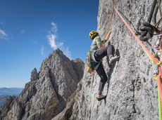
This well-secured sport climbing route features interesting lines in prime rock.
Alpine klimroutes
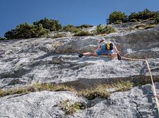
This tour is rich in variety and includes slabs, water grooves, as well as a strong overhang and a traverse with an undercling passage.
Alpine klimroutes
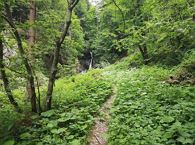
Short hike to the waterfall in the Breuergraben along the Schwarzache.
Brandstadlbahn valley station, Scheffau (681 m)
Brandstadlbahn valley station, Scheffau (681 m)
Wandelen
Gemakkelijk
1:00 u
3,0 km
150 Hoogtemeters
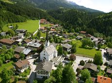
A running circuit from Scheffau towards Ellmau via the Auwald district.
Starting point Scheffau Tourist Information Office (752 m)
Starting point Scheffau Tourist Information Office (752 m)
Hardlopen
Gemakkelijk
7,7 km
180 Hoogtemeters
Gaudeamushütte – Gamswegl – path 825 – Gruttenhütte
Gaudeamushütte, Going (1,263 m)
Gruttenhütte, Ellmau (1,620 m)
Wandelen
Normaal
1:45 u
3,2 km
480 Hoogtemeters
Hike from the Kaiserlift mountain station via the Kaindlhütte and Walleralm to Hintersteiner See.
Mountain station Kaiserlift, Kufstein (1256 m)
Hiking starting point Seestüberl, Scheffau (890 m)
Wandelen
Normaal
3:20 u
8,8 km
340 Hoogtemeters
Going, Hüttling - Schleierwasserfall - Obere Regalm - Baumgartenköpfl (Bergsteigergrab) - Gaudeamushütte - Ellmauer Tor - Hintere Goinger Halt - Jubiläumssteig - Gruttenhütte - Kaiser-Hochalm - Steiner-Hochalm - Hinterschießling Alm - Rehbachklamm - Scheffau, Dorf
Hiking starting point Hüttling, Going (820 m)
Scheffau village (738 m)
Wandelen
Moeilijk
14:00 u
24,6 km
2060 Hoogtemeters
Ellmau Tourist Information Office - golf course - Wochenbrunner Alm
Tourist Information Office, Ellmau (800 m)
Wochenbrunner Alm, Ellmau (1,085 m)
Fietsen
Normaal
4,8 km
260 Hoogtemeters

Explore the village Scheffau on a circuit run
Starting point Scheffau Tourist Information Office (752 m)
Starting point Scheffau Tourist Information Office (752 m)
Hardlopen
Gemakkelijk
5,6 km
120 Hoogtemeters
Via ferrata

A beautiful easy hike at the foot of the Wilder Kaiser
Hiking starting point Tourist Info, Ellmau (800 m)
Hiking starting point Tourist Info, Ellmau (800 m)
Wandelen
Gemakkelijk
1:45 u
5,9 km
60 Hoogtemeters