


 Deutsch
 English
Sappl-Zott Tour für Abenteurer route
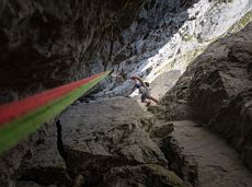
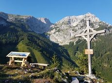
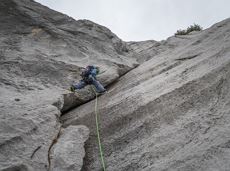
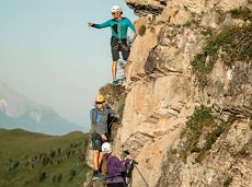
The heart of the tour is the deep, wonderful-to-climb chimney, which lends the tour an Alpine character.
Alpine klimroutes
De door u opgevraagde pagina is niet beschikbaar. U bent welkom om een nieuwe zoekopdracht op deze pagina te starten.
The heart of the tour is the deep, wonderful-to-climb chimney, which lends the tour an Alpine character.
Alpine klimroutes

Soccer field, Söll (687 m)
Soccer field, Söll (687 m)
Hardlopen
Gemakkelijk
2,5 km
30 Hoogtemeters
Stripsenjochhaus – Stripsenkopf – Feldberg – Scheibenbichlalmen – Griesenau – Gasteig
Stripsenjochhaus, St. Johann in Tirol (1,577 m)
Gasteig (750 m)
Wandelen
Normaal
6:30 u
16,1 km
640 Hoogtemeters
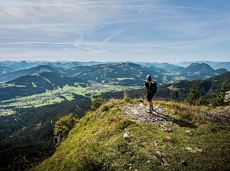
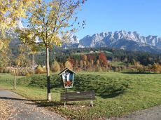
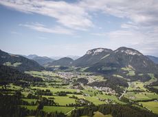
Experience the picturesque beauty of a section of the Lengau Reflection Trail, which takes you along a steep route to the famous Söller Sunnseitweg.
Wanderstartplatz
Wanderstartplatz Alpenschlössl, Söll (762 m)
Wandelen
Normaal
2:15 u
5,7 km
340 Hoogtemeters
 Gedeeltelijk open
Calling bike fans of all ability levels! The Kaiser circular cycling route is an 80-kilometre bike route through the spectacular scenery of the Kaisergebirge mountain range. An excellent network of well-signposted trails (a mix of asphalt and gravel paths) leads past idyllic nature, breathtaking panoramas and cultural sights. For relaxing moments in between stages, cool lakes and local restaurants invite you to linger and enjoy.
anywhere along the tour
anywhere along the tour
Fietsen
Normaal
6:45 u
85,6 km
700 Hoogtemeters
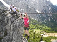
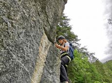
This 3-part Via Ferrata features a rope bridge and an extremely difficult exit option.
Via ferrata
GeslotenVia ferrata

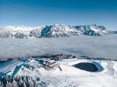
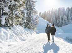
Skiing or hiking on the cross-country trail isn’t possible when there’s been too little snow on the sunny side. In this case there’s a perfectly prepared trail available on the shaded side - the Dorfloipe Going.
Infobüro Going,
Wanderstartplatz Infobüro, Going (764 m)
Langlaufen
Gemakkelijk
1,4 km
20 Hoogtemeters
A short winter walk on Hartkaiser hrough Ellmi's magical world.
Hiking starting point Tourist Info, Ellmau (800 m)
Hiking starting point Tourist Info, Ellmau (800 m)
Wandelen
Gemakkelijk
0:30 u
1,0 km
25 Hoogtemeters

With the Söller Zehner (1st competition in the Tour de Tirol) the circuit is run three times!
Hiking starting point Tourist Info, Söll (689 m)
Hiking starting point Tourist Info, Söll (689 m)
Hardlopen
Gemakkelijk
3,3 km
80 Hoogtemeters

Old path - now renovated and featuring a pleasant series of ascents and descents.
Hiking starting point Bergbahn, Söll (725 m)
Hiking starting point Bergbahn, Söll (725 m)
Wandelen
Normaal
4:30 u
13,5 km
470 Hoogtemeters
Sports ground, Söll (687 m)
Sports ground, Söll (687 m)
Hardlopen
Gemakkelijk
8,4 km
130 Hoogtemeters
OpenVia ferrata
 aanbevolen
A tour of the main filming locations of the TV series “Der Bergdoktor” (The Mountain Doctor) in Ellmau and Going, with a refreshment stop at the inn used during filming
Hiking info point, Tourist Info Ellmau (800 m)
Hiking info point, Tourist Info Ellmau (800 m)
Wandelen
Gemakkelijk
3:15 u
11,4 km
180 Hoogtemeters
Comfortable round with a magnificent view of the Hohe Salve.
Mountain station gondola Hexenwasser, Söll (1,150 m)
Mountain station gondola Hexenwasser, Söll (1,150 m)
Wandelen
Gemakkelijk
0:35 u
1,8 km
50 Hoogtemeters
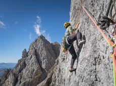
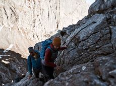
This well-secured sport climbing route features interesting lines in prime rock.
Alpine klimroutes
Wilder Kaiser hike to a series of special locations. Featuring the natural spectacle of the Schleier Waterfall and a view of the Gaudeamushütte mountain hut.
Hüttling, Going (820 m)
Hüttling, Going (820 m)
Wandelen
Normaal
6:00 u
13,6 km
980 Hoogtemeters
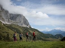
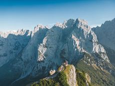
Sturdy boots will help keep your ankles and feet happy on this hike, full of the best things Tirol has to offer: well-maintained trails, wildflowers galore and waterfalls beckon the adventurous hiker ready for a strenuous climb with breathtaking views of lofty Wilder Kaiser Mountain Range as your reward. The nature reserve’s landscape will win you over with its diverse beauty. The pasture regions are covered with soft grassy meadows, and hikers are greeted by lofty Wilder Kaiser Mountain Range with rugged Maukspitze, Ackerlspitze, Regalpspitze and Törlspitze Peaks, all “Two-Thousanders” that average 2,000 metres altitude. Trailhead is Rummlerhof Inn, northwest of the village centre of St. Johann. After a successful first segment, why not take a rest at Gaudeamus Hut, raise your glass and sing: “Gaudeamus igitur – Let us be happy!” For many hikers this is far enough, contentment has already set in. Adventurous souls continue on the trail that works its way up across Klamml Gorge to Grutten Hut, which entails another 400 metres of climbing.
Rummlerhof, St.Johann in Tirol
Gaudeamushütte
Wandelen
Normaal
5:00 u
13,0 km
1060 Hoogtemeters

An extensive exploration of the “Moor & more”. Exciting puzzle tour with Rocky through the Kaiserwald forest is sure to be lots of fun, even for older children.
Hiking starting point Hüttling, Going (820 m)
Hiking starting point Hüttling, Going (820 m)
Wandelen
Gemakkelijk
3:00 u
8,0 km
380 Hoogtemeters
Quietness, strength and with easy breathing steadily closer to the Wilder Kaiser. You can return on foot or by bus.
Hiking starting point Bergbahn, Söll (724 m)
Gasthof Bocking, Söll (665 m)
Wandelen
Gemakkelijk
1:45 u
5,5 km
100 Hoogtemeters
A circuit around the mountain that the locals love for its great view.
Hiking starting point Franzlhof, Söll (703 m)
Hiking starting point Franzlhof, Söll (703 m)
Wandelen
Normaal
6:00 u
17,8 km
670 Hoogtemeters
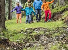
Family roundtrip through the Rebachklamm to the Seilabodenkreuz, via the Kaiseralm and the Jägerwirt back to the center of Scheffau.
Community Hall, Scheffau (740 m)
Community Hall, Scheffau (740 m)
Wandelen
Normaal
3:15 u
9,7 km
510 Hoogtemeters
 Gedeeltelijk open
Varied round tour with many refreshments and wonderful views
Tourist Information Office, Scheffau (737 m)
Tourist Information Office, Scheffau (737 m)
Fietsen
Normaal
23,6 km
660 Hoogtemeters
Enjoy unique panoramic views of the impressive mountains from the Biedringer Platte plateau.
Hiking starting point Tourist Info, Ellmau (800 m)
Hiking starting point Tourist Info, Ellmau (800 m)
Wandelen
Gemakkelijk
4:15 u
12,6 km
470 Hoogtemeters

Alpine klimroutes
 Open
OpenVia ferrata
Ellmau Tourist Information Office - golf course - Wochenbrunner Alm
Tourist Information Office, Ellmau (800 m)
Wochenbrunner Alm, Ellmau (1,085 m)
Fietsen
Normaal
4,8 km
260 Hoogtemeters

Kaindlhütte - Bettlersteig - Anton-Karg-Haus - Hans-Berger-Haus - Stripsenjochhaus
Hintersteiner See, Scheffau (889 m)
Stripsenjochhaus, St. Johann in Tirol (1,577 m)
Wandelen
Normaal
5:00 u
9,3 km
840 Hoogtemeters
 Gedeeltelijk open
Varied and challenging loop over the Scheffauer summit.
Kaindlhütte, Scheffau (1,293 m)
Scheffauer (2,111 m)
Wandelen
Moeilijk
8:30 u
13,0 km
1400 Hoogtemeters
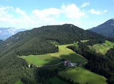
2 villages - you fancy quiete and a very rural athmosphere - Scheffau is the place to go, or, you opt for a great variety of gastronomy and restaurants - then Söll is good to go. No matter how, your decision is always superb. The ski hiking route is purely flat, which also means it's great for everybody.
restaurant Oberstegen, Söll
village, Scheffau
Langlaufen
Gemakkelijk
1,4 km
15 Hoogtemeters
A nice run around the crystal-clear lake Hintersteiner See.
Starting point Seestüberl, Scheffau (822 m)
Starting point Seestüberl, Scheffau (882 m)
Hardlopen
Gemakkelijk
5,2 km
180 Hoogtemeters
Alpine klimroutes
Stripsenjochhaus – Eggersteig – Steinerne Rinne – Ellmauer Tor – Jubiläumssteig – Gruttenhütte
Stripsenjochhaus, St. Johann in Tirol (1,577 m)
Gaudeamushütte, Going (1,263 m)
Wandelen
Moeilijk
5:00 u
6,3 km
590 Hoogtemeters
Gaudeamushütte - Ellmauer Tor - Hintere Goinger Halt - Jubiläumssteig - Gruttenhütte
Gaudeamushütte, Going (1,263 m)
Gruttenhütte, Ellmau (1,620 m)
Wandelen
Moeilijk
5:30 u
5,9 km
1010 Hoogtemeters
Experience culinaric highlights for the whole family.
Bergstation Rabennest (1.150 m)
Bergstation Rabennest (1.150 m)
Wandelen
Gemakkelijk
0:40 u
1,7 km
90 Hoogtemeters
Sports ground, Söll (687 m)
Sports ground, Söll (687 m)
Hardlopen
Gemakkelijk
3,0 km
70 Hoogtemeters
 Gesloten
The Kitzbüheler Horn Via Ferrata offers a Magnificent Climbing Adventure for Less Experienced Climbers. Enjoy Spectacular Views and Adrenaline Rushes while being Safe and Secure throughout Your Journey.
Via ferrata

Fork 823/826 – via waterfall – Veitskirche – Steiner-Hochalm
Fork on the Wilder-Kaiser-Steig 823/826 (1,405 m)
Steiner-Hochalm, Scheffau (1,257 m)
Wandelen
Normaal
2:30 u
3,8 km
360 Hoogtemeters
This pleasant circular walk takes you to Söll’s war memorial in a beautiful section of forest.
Hiking starting point Tourist Info, Söll (689 m)
Hiking starting point Tourist Info, Söll (689 m)
Wandelen
Gemakkelijk
0:30 u
2,1 km
10 Hoogtemeters
Hike via four mountain huts Rübezahl-Alm, Jägerhütte and Hochschwendt.
Hiking starting point Tourist Info, Ellmau (800 m)
Hiking starting point Tourist Info, Ellmau (800 m)
Wandelen
Gemakkelijk
6:15 u
14,0 km
600 Hoogtemeters