


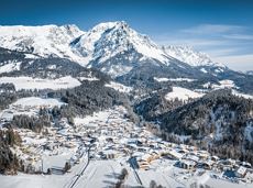
 Deutsch
 English
Sportherz route

Alpine klimroutes
De door u opgevraagde pagina is niet beschikbaar. U bent welkom om een nieuwe zoekopdracht op deze pagina te starten.
De door u opgevraagde pagina is niet beschikbaar. U bent welkom om een nieuwe zoekopdracht op deze pagina te starten.
Alpine klimroutes
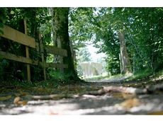
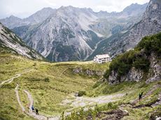
Extended walk through the landscape of Scheffau and Söll
Hiking starting point Tourist Info, Scheffau (738 m)
Hiking starting point Tourist Info, Scheffau (738 m)
Wandelen
3:30 u
8,8 km
210 Hoogtemeters
This familyfriendly hike leads you along the panoramic trail from the Brandstadl mountain in Scheffau to the Hartkaiser mountain in Ellmau.
Brandstadlbahn mountain station, Scheffau (1,650 m) or Hartkaiserbahn mountain station, Ellmau (1.550 m)
Brandstadlbahn mountain station, Scheffau (1,650 m) or Hartkaiserbahn mountain station, Ellmau (1.550 m)
Wandelen
Gemakkelijk
1:50 u
6,0 km
170 Hoogtemeters
Kufstein – Brentenjoch – Kaindlhütte
Kaiserlift summit station, Kufstein (1,255 m)
Kaindlhütte, Scheffau (1,293 m)
Wandelen
Gemakkelijk
1:30 u
2,9 km
220 Hoogtemeters

An adventure hike from Ellmau village centre to the Wochenbrunner Alm mountain hut from where you can enjoy stunning views and the Ellmau Stone Circle.
Hiking starting point Tourist Info, Ellmau (800 m)
Hiking starting point Tourist Info, Ellmau (800 m)
Wandelen
Gemakkelijk
4:30 u
13,5 km
530 Hoogtemeters

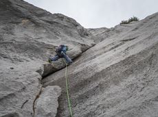
Beautiful, Alpine sport climbing with consistent difficulty.
Alpine klimroutes
Alpine klimroutes
A must for hikers in Söll - local history and culinary delights on the sunny side.
Hiking starting point Franzlhof, Söll (703 m)
Hiking starting point Franzlhof, Söll (703 m)
Wandelen
Normaal
3:45 u
11,0 km
420 Hoogtemeters

Embark on a sunny cross-country safari in the snowfields around the Sölllandl.
Spar super market Söll
Spar super market Söll
Langlaufen
Normaal
5,9 km
70 Hoogtemeters

Sports ground, Söll (687 m)
Sports ground, Söll (687 m)
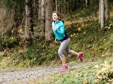
Hardlopen
Gemakkelijk
3,0 km
70 Hoogtemeters
Gentle walking or running course in Ellmau
Hiking starting point Tourist Info, Ellmau (800 m)
Hiking starting point Tourist Info, Ellmau (800 m)
Hardlopen
Gemakkelijk
0:20 u
3,0 km
54 Hoogtemeters

The varied loop takes you on leisurely valley cycle paths as well as a mountain evaluation on the MTB routes 265 and 350 once around the Hohe Salve lookout mountain.
Tourismus Info, Söll
Tour
Fietsen
Normaal
36,5 km
880 Hoogtemeters
 Gesloten
Moderately difficult ascent route along the ski route 80c/d to the Hartkaiser.
Hartkaiserbahn valley station, Ellmau (824 m)
Hartkaiserbahn mountain station, Ellmau (1.524 m)
Skitocht
Normaal
2:30 u
4,2 km
700 Hoogtemeters
The Anna Grotto is hidden in the middle of a forest at the very foot of the Wilder Kaiser.
Wochenbrunner Alm, Ellmau (1,085 m)
Wochenbrunner Alm, Ellmau (1,085 m)
Wandelen
Gemakkelijk
0:20 u
0,7 km
50 Hoogtemeters
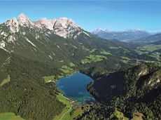
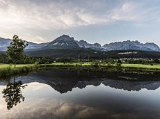
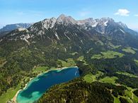
A picturesque mountain hike that leads from the turquoise waters of the most beautiful mountain lake in Tirol up to the rustic Alpine village.
Hiking starting point Seestüberl, Scheffau (890 m)
Hiking starting point Seestüberl, Scheffau (890 m)
Wandelen
Normaal
3:15 u
9,3 km
360 Hoogtemeters
Gaudeamushütte - Ellmauer Tor - Hintere Goinger Halt - Jubiläumssteig - Gruttenhütte
Gaudeamushütte, Going (1,263 m)
Gruttenhütte, Ellmau (1,620 m)
Wandelen
Moeilijk
5:30 u
5,9 km
1010 Hoogtemeters
Going, Hüttling - Schleierwasserfall - Obere Regalm - Baumgartenköpfl (Bergsteigergrab) - Gaudeamushütte - Ellmauer Tor - Hintere Goinger Halt - Jubiläumssteig - Gruttenhütte - Kaiser-Hochalm - Steiner-Hochalm - Hinterschießling Alm - Rehbachklamm - Scheffau, Dorf
Hiking starting point Hüttling, Going (820 m)
Scheffau village (738 m)
Wandelen
Moeilijk
14:00 u
24,6 km
2060 Hoogtemeters
The heart of the tour is the deep, wonderful-to-climb chimney, which lends the tour an Alpine character.
Alpine klimroutes
Over hill and dale through idyllic nature up to the Rauhen Kopf.
Astberg Bergstation
Astberg Bergstation
Wandelen
Normaal
4:45 u
13,1 km
620 Hoogtemeters
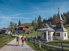
Experience the picturesque beauty of a section of the Lengau Reflection Trail, which takes you along a steep route to the famous Söller Sunnseitweg.
Wanderstartplatz
Wanderstartplatz Alpenschlössl, Söll (762 m)
Wandelen
Normaal
2:15 u
5,7 km
340 Hoogtemeters
"Enjoyable" winter hike with a cozy stop and a fantastic panorama.
Hiking starting point Tourist Info, Ellmau (800 m)
Hiking starting point Tourist Info, Ellmau (800 m)
Wandelen
4:30 u
10,5 km
370 Hoogtemeters
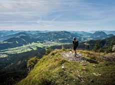
Enjoy unique panoramic views of the impressive mountains from the Biedringer Platte plateau.
Hiking starting point Tourist Info, Ellmau (800 m)
Hiking starting point Tourist Info, Ellmau (800 m)
Wandelen
Gemakkelijk
4:15 u
12,6 km
470 Hoogtemeters
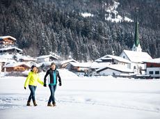
Explore the popular path past the TV backdrop on snowshoes.
Cable car valley station, Söll (725 m)
Cable car valley station, Söll (725 m)
Wandelen
4:45 u
7,0 km
350 Hoogtemeters
Through the winter forest to the wildlife park at the Wochenbrunner Alm.
Hiking starting point Tourist Info, Ellmau (800 m)
Hiking starting point Tourist Info, Ellmau (800 m)
Wandelen
3:30 u
9,0 km
300 Hoogtemeters
 aanbevolen
Explore the districts of Paisslberg and Ried on a leisurely hike for everyone.
Hiking starting point Alpenschlössl, Söll (762 m)
Hiking starting point Alpenschlössl, Söll (762 m)
Wandelen
Gemakkelijk
1:30 u
4,4 km
100 Hoogtemeters

With the Söller Zehner (1st competition in the Tour de Tirol) the circuit is run three times!
Hiking starting point Tourist Info, Söll (689 m)
Hiking starting point Tourist Info, Söll (689 m)
Hardlopen
Gemakkelijk
3,3 km
80 Hoogtemeters
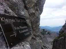
Demanding mountain tour to the Kleines Törl pass, the little "brother" of the Ellmauer Tor in the Ostkaiser.
Hiking starting point Tannbichl, Going (855 m)
Hiking starting point Tannbichl, Going (855 m)
Wandelen
Moeilijk
8:00 u
12,0 km
1260 Hoogtemeters
 aanbevolen
Hike along the sunny side along field paths and settlements from Scheffau to Ellmau..
Hiking starting point, Tourismus Info, Scheffau (737 m)
Bus stop Ellmau Bauhof/Dorf, Ellmau (800 m)
Wandelen
Gemakkelijk
1:30 u
5,7 km
100 Hoogtemeters

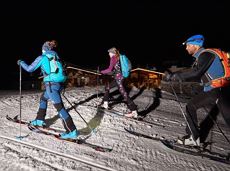
Imperial glide during the day and at night - on the only night trail.
Langlaufen
Gemakkelijk
1,2 km
30 Hoogtemeters
Ellmau hiking info - Church - Gasthof Au - Forstmeile Ellmau
Hiking starting point Tourist Info, Ellmau (800 m)
Hiking starting point Tourist Info, Ellmau (800 m)
Hardlopen
Gemakkelijk
5,5 km
150 Hoogtemeters
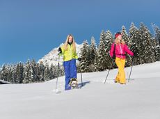
Easy snowshoe hike at the foot of the Wilder Kaiser.
Postbus stop Dorf/Bauhof, Ellmau
Postbus stop Dorf/Bauhof, Ellmau
Wandelen
0:40 u
1,3 km
10 Hoogtemeters
A gentle walk to ancient farmsteads with a refreshment stop in a welcoming inn.
Hiking starting point Tourist Info, Scheffau (738 m)
Hiking starting point Tourist Info, Scheffau (738 m)
Wandelen
1:30 u
3,8 km
80 Hoogtemeters
Ellmau Tourist Information Office - football pitch - Ellmauer Hof - KaiserBad - Hausbach farms - Ellmau Tourist Information Office
Tourist Information Office, Ellmau (820 m)
Tourist Information Office, Ellmau (820 m)
Fietsen
Gemakkelijk
8,2 km
110 Hoogtemeters
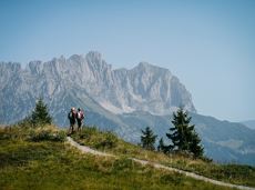
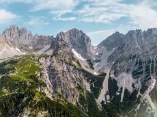
Hikers exploring Tirol on foot will feel as free as a bird. The eagle walk is one of the 'Great Walks' of Tyrol chosen by a jury. They offer hikers the chance to get away from it all, discover the beauty of nature and experience a true adventure in the Alps.
St. Johann in Tirol
Arlbergpass
Wandelen
Moeilijk
426,0 km
30000 Hoogtemeters
Wilder Kaiser hike to a series of special locations. Featuring the natural spectacle of the Schleier Waterfall and a view of the Gaudeamushütte mountain hut.
Hüttling, Going (820 m)
Hüttling, Going (820 m)
Wandelen
Normaal
6:00 u
13,6 km
980 Hoogtemeters
Quietness, strength and with easy breathing steadily closer to the Wilder Kaiser. You can return on foot or by bus.
Hiking starting point Bergbahn, Söll (724 m)
Gasthof Bocking, Söll (665 m)
Wandelen
Gemakkelijk
1:45 u
5,5 km
100 Hoogtemeters
A nice run around the crystal-clear lake Hintersteiner See.
Starting point Seestüberl, Scheffau (822 m)
Starting point Seestüberl, Scheffau (882 m)
Hardlopen
Gemakkelijk
5,2 km
180 Hoogtemeters
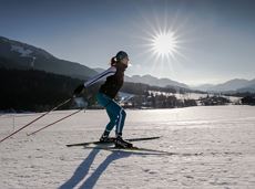
2 villages - you fancy quiete and a very rural athmosphere - Scheffau is the place to go, or, you opt for a great variety of gastronomy and restaurants - then Söll is good to go. No matter how, your decision is always superb. The ski hiking route is purely flat, which also means it's great for everybody.
restaurant Oberstegen, Söll
village, Scheffau
Langlaufen
Gemakkelijk
1,4 km
15 Hoogtemeters
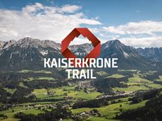
The Kaiserkrone Trail is a trail running event with several competitions that lead around the Wilder Kaiser mountain massif. More about the event at: www.kaiserkrone.run
Start & Finish - village center of Scheffau (732 m), address: Dorf 45, 6351 Scheffau
Start & Finish - village center of Scheffau (732 m), address: Dorf 45, 6351 Scheffau
Hardlopen
Moeilijk
56,0 km
3640 Hoogtemeters
An ascent that is rewarded with refreshments. Back to the valley with the toboggan, the lift or on foot.
Village centre, Ellmau (800 m)
Astbergbahn, Going (804 m)
Wandelen
2:45 u
5,8 km
460 Hoogtemeters
De door u opgevraagde pagina is niet beschikbaar. U bent welkom om een nieuwe zoekopdracht op deze pagina te starten.
Alpine klimroutes
Extended walk through the landscape of Scheffau and Söll
Hiking starting point Tourist Info, Scheffau (738 m)
Hiking starting point Tourist Info, Scheffau (738 m)
Wandelen
3:30 u
8,8 km
210 Hoogtemeters
This familyfriendly hike leads you along the panoramic trail from the Brandstadl mountain in Scheffau to the Hartkaiser mountain in Ellmau.
Brandstadlbahn mountain station, Scheffau (1,650 m) or Hartkaiserbahn mountain station, Ellmau (1.550 m)
Brandstadlbahn mountain station, Scheffau (1,650 m) or Hartkaiserbahn mountain station, Ellmau (1.550 m)
Wandelen
Gemakkelijk
1:50 u
6,0 km
170 Hoogtemeters
Kufstein – Brentenjoch – Kaindlhütte
Kaiserlift summit station, Kufstein (1,255 m)
Kaindlhütte, Scheffau (1,293 m)
Wandelen
Gemakkelijk
1:30 u
2,9 km
220 Hoogtemeters
An adventure hike from Ellmau village centre to the Wochenbrunner Alm mountain hut from where you can enjoy stunning views and the Ellmau Stone Circle.
Hiking starting point Tourist Info, Ellmau (800 m)
Hiking starting point Tourist Info, Ellmau (800 m)
Wandelen
Gemakkelijk
4:30 u
13,5 km
530 Hoogtemeters
Beautiful, Alpine sport climbing with consistent difficulty.
Alpine klimroutes
Alpine klimroutes
A must for hikers in Söll - local history and culinary delights on the sunny side.
Hiking starting point Franzlhof, Söll (703 m)
Hiking starting point Franzlhof, Söll (703 m)
Wandelen
Normaal
3:45 u
11,0 km
420 Hoogtemeters
Embark on a sunny cross-country safari in the snowfields around the Sölllandl.
Spar super market Söll
Spar super market Söll
Langlaufen
Normaal
5,9 km
70 Hoogtemeters
Sports ground, Söll (687 m)
Sports ground, Söll (687 m)
Hardlopen
Gemakkelijk
3,0 km
70 Hoogtemeters
Gentle walking or running course in Ellmau
Hiking starting point Tourist Info, Ellmau (800 m)
Hiking starting point Tourist Info, Ellmau (800 m)
Hardlopen
Gemakkelijk
0:20 u
3,0 km
54 Hoogtemeters
The varied loop takes you on leisurely valley cycle paths as well as a mountain evaluation on the MTB routes 265 and 350 once around the Hohe Salve lookout mountain.
Tourismus Info, Söll
Tour
Fietsen
Normaal
36,5 km
880 Hoogtemeters
GeslotenModerately difficult ascent route along the ski route 80c/d to the Hartkaiser.
Hartkaiserbahn valley station, Ellmau (824 m)
Hartkaiserbahn mountain station, Ellmau (1.524 m)
Skitocht
Normaal
2:30 u
4,2 km
700 Hoogtemeters
The Anna Grotto is hidden in the middle of a forest at the very foot of the Wilder Kaiser.
Wochenbrunner Alm, Ellmau (1,085 m)
Wochenbrunner Alm, Ellmau (1,085 m)
Wandelen
Gemakkelijk
0:20 u
0,7 km
50 Hoogtemeters
A picturesque mountain hike that leads from the turquoise waters of the most beautiful mountain lake in Tirol up to the rustic Alpine village.
Hiking starting point Seestüberl, Scheffau (890 m)
Hiking starting point Seestüberl, Scheffau (890 m)
Wandelen
Normaal
3:15 u
9,3 km
360 Hoogtemeters
Gaudeamushütte - Ellmauer Tor - Hintere Goinger Halt - Jubiläumssteig - Gruttenhütte
Gaudeamushütte, Going (1,263 m)
Gruttenhütte, Ellmau (1,620 m)
Wandelen
Moeilijk
5:30 u
5,9 km
1010 Hoogtemeters
Going, Hüttling - Schleierwasserfall - Obere Regalm - Baumgartenköpfl (Bergsteigergrab) - Gaudeamushütte - Ellmauer Tor - Hintere Goinger Halt - Jubiläumssteig - Gruttenhütte - Kaiser-Hochalm - Steiner-Hochalm - Hinterschießling Alm - Rehbachklamm - Scheffau, Dorf
Hiking starting point Hüttling, Going (820 m)
Scheffau village (738 m)
Wandelen
Moeilijk
14:00 u
24,6 km
2060 Hoogtemeters
The heart of the tour is the deep, wonderful-to-climb chimney, which lends the tour an Alpine character.
Alpine klimroutes
Over hill and dale through idyllic nature up to the Rauhen Kopf.
Astberg Bergstation
Astberg Bergstation
Wandelen
Normaal
4:45 u
13,1 km
620 Hoogtemeters
Experience the picturesque beauty of a section of the Lengau Reflection Trail, which takes you along a steep route to the famous Söller Sunnseitweg.
Wanderstartplatz
Wanderstartplatz Alpenschlössl, Söll (762 m)
Wandelen
Normaal
2:15 u
5,7 km
340 Hoogtemeters
"Enjoyable" winter hike with a cozy stop and a fantastic panorama.
Hiking starting point Tourist Info, Ellmau (800 m)
Hiking starting point Tourist Info, Ellmau (800 m)
Wandelen
4:30 u
10,5 km
370 Hoogtemeters
Enjoy unique panoramic views of the impressive mountains from the Biedringer Platte plateau.
Hiking starting point Tourist Info, Ellmau (800 m)
Hiking starting point Tourist Info, Ellmau (800 m)
Wandelen
Gemakkelijk
4:15 u
12,6 km
470 Hoogtemeters
Explore the popular path past the TV backdrop on snowshoes.
Cable car valley station, Söll (725 m)
Cable car valley station, Söll (725 m)
Wandelen
4:45 u
7,0 km
350 Hoogtemeters
Through the winter forest to the wildlife park at the Wochenbrunner Alm.
Hiking starting point Tourist Info, Ellmau (800 m)
Hiking starting point Tourist Info, Ellmau (800 m)
Wandelen
3:30 u
9,0 km
300 Hoogtemeters
aanbevolenExplore the districts of Paisslberg and Ried on a leisurely hike for everyone.
Hiking starting point Alpenschlössl, Söll (762 m)
Hiking starting point Alpenschlössl, Söll (762 m)
Wandelen
Gemakkelijk
1:30 u
4,4 km
100 Hoogtemeters
With the Söller Zehner (1st competition in the Tour de Tirol) the circuit is run three times!
Hiking starting point Tourist Info, Söll (689 m)
Hiking starting point Tourist Info, Söll (689 m)
Hardlopen
Gemakkelijk
3,3 km
80 Hoogtemeters
Demanding mountain tour to the Kleines Törl pass, the little "brother" of the Ellmauer Tor in the Ostkaiser.
Hiking starting point Tannbichl, Going (855 m)
Hiking starting point Tannbichl, Going (855 m)
Wandelen
Moeilijk
8:00 u
12,0 km
1260 Hoogtemeters
aanbevolenHike along the sunny side along field paths and settlements from Scheffau to Ellmau..
Hiking starting point, Tourismus Info, Scheffau (737 m)
Bus stop Ellmau Bauhof/Dorf, Ellmau (800 m)
Wandelen
Gemakkelijk
1:30 u
5,7 km
100 Hoogtemeters
Imperial glide during the day and at night - on the only night trail.
Langlaufen
Gemakkelijk
1,2 km
30 Hoogtemeters
Ellmau hiking info - Church - Gasthof Au - Forstmeile Ellmau
Hiking starting point Tourist Info, Ellmau (800 m)
Hiking starting point Tourist Info, Ellmau (800 m)
Hardlopen
Gemakkelijk
5,5 km
150 Hoogtemeters
Easy snowshoe hike at the foot of the Wilder Kaiser.
Postbus stop Dorf/Bauhof, Ellmau
Postbus stop Dorf/Bauhof, Ellmau
Wandelen
0:40 u
1,3 km
10 Hoogtemeters
A gentle walk to ancient farmsteads with a refreshment stop in a welcoming inn.
Hiking starting point Tourist Info, Scheffau (738 m)
Hiking starting point Tourist Info, Scheffau (738 m)
Wandelen
1:30 u
3,8 km
80 Hoogtemeters
Ellmau Tourist Information Office - football pitch - Ellmauer Hof - KaiserBad - Hausbach farms - Ellmau Tourist Information Office
Tourist Information Office, Ellmau (820 m)
Tourist Information Office, Ellmau (820 m)
Fietsen
Gemakkelijk
8,2 km
110 Hoogtemeters
Hikers exploring Tirol on foot will feel as free as a bird. The eagle walk is one of the 'Great Walks' of Tyrol chosen by a jury. They offer hikers the chance to get away from it all, discover the beauty of nature and experience a true adventure in the Alps.
St. Johann in Tirol
Arlbergpass
Wandelen
Moeilijk
426,0 km
30000 Hoogtemeters
Wilder Kaiser hike to a series of special locations. Featuring the natural spectacle of the Schleier Waterfall and a view of the Gaudeamushütte mountain hut.
Hüttling, Going (820 m)
Hüttling, Going (820 m)
Wandelen
Normaal
6:00 u
13,6 km
980 Hoogtemeters
Quietness, strength and with easy breathing steadily closer to the Wilder Kaiser. You can return on foot or by bus.
Hiking starting point Bergbahn, Söll (724 m)
Gasthof Bocking, Söll (665 m)
Wandelen
Gemakkelijk
1:45 u
5,5 km
100 Hoogtemeters
A nice run around the crystal-clear lake Hintersteiner See.
Starting point Seestüberl, Scheffau (822 m)
Starting point Seestüberl, Scheffau (882 m)
Hardlopen
Gemakkelijk
5,2 km
180 Hoogtemeters
2 villages - you fancy quiete and a very rural athmosphere - Scheffau is the place to go, or, you opt for a great variety of gastronomy and restaurants - then Söll is good to go. No matter how, your decision is always superb. The ski hiking route is purely flat, which also means it's great for everybody.
restaurant Oberstegen, Söll
village, Scheffau
Langlaufen
Gemakkelijk
1,4 km
15 Hoogtemeters
The Kaiserkrone Trail is a trail running event with several competitions that lead around the Wilder Kaiser mountain massif. More about the event at: www.kaiserkrone.run
Start & Finish - village center of Scheffau (732 m), address: Dorf 45, 6351 Scheffau
Start & Finish - village center of Scheffau (732 m), address: Dorf 45, 6351 Scheffau
Hardlopen
Moeilijk
56,0 km
3640 Hoogtemeters
An ascent that is rewarded with refreshments. Back to the valley with the toboggan, the lift or on foot.
Village centre, Ellmau (800 m)
Astbergbahn, Going (804 m)
Wandelen
2:45 u
5,8 km
460 Hoogtemeters
Alpine klimroutes
Extended walk through the landscape of Scheffau and Söll
Hiking starting point Tourist Info, Scheffau (738 m)
Hiking starting point Tourist Info, Scheffau (738 m)
Wandelen
3:30 u
8,8 km
210 Hoogtemeters
This familyfriendly hike leads you along the panoramic trail from the Brandstadl mountain in Scheffau to the Hartkaiser mountain in Ellmau.
Brandstadlbahn mountain station, Scheffau (1,650 m) or Hartkaiserbahn mountain station, Ellmau (1.550 m)
Brandstadlbahn mountain station, Scheffau (1,650 m) or Hartkaiserbahn mountain station, Ellmau (1.550 m)
Wandelen
Gemakkelijk
1:50 u
6,0 km
170 Hoogtemeters
Kufstein – Brentenjoch – Kaindlhütte
Kaiserlift summit station, Kufstein (1,255 m)
Kaindlhütte, Scheffau (1,293 m)
Wandelen
Gemakkelijk
1:30 u
2,9 km
220 Hoogtemeters
An adventure hike from Ellmau village centre to the Wochenbrunner Alm mountain hut from where you can enjoy stunning views and the Ellmau Stone Circle.
Hiking starting point Tourist Info, Ellmau (800 m)
Hiking starting point Tourist Info, Ellmau (800 m)
Wandelen
Gemakkelijk
4:30 u
13,5 km
530 Hoogtemeters
Beautiful, Alpine sport climbing with consistent difficulty.
Alpine klimroutes
Alpine klimroutes
A must for hikers in Söll - local history and culinary delights on the sunny side.
Hiking starting point Franzlhof, Söll (703 m)
Hiking starting point Franzlhof, Söll (703 m)
Wandelen
Normaal
3:45 u
11,0 km
420 Hoogtemeters
Embark on a sunny cross-country safari in the snowfields around the Sölllandl.
Spar super market Söll
Spar super market Söll
Langlaufen
Normaal
5,9 km
70 Hoogtemeters
Sports ground, Söll (687 m)
Sports ground, Söll (687 m)
Hardlopen
Gemakkelijk
3,0 km
70 Hoogtemeters
Gentle walking or running course in Ellmau
Hiking starting point Tourist Info, Ellmau (800 m)
Hiking starting point Tourist Info, Ellmau (800 m)
Hardlopen
Gemakkelijk
0:20 u
3,0 km
54 Hoogtemeters
The varied loop takes you on leisurely valley cycle paths as well as a mountain evaluation on the MTB routes 265 and 350 once around the Hohe Salve lookout mountain.
Tourismus Info, Söll
Tour
Fietsen
Normaal
36,5 km
880 Hoogtemeters
GeslotenModerately difficult ascent route along the ski route 80c/d to the Hartkaiser.
Hartkaiserbahn valley station, Ellmau (824 m)
Hartkaiserbahn mountain station, Ellmau (1.524 m)
Skitocht
Normaal
2:30 u
4,2 km
700 Hoogtemeters
The Anna Grotto is hidden in the middle of a forest at the very foot of the Wilder Kaiser.
Wochenbrunner Alm, Ellmau (1,085 m)
Wochenbrunner Alm, Ellmau (1,085 m)
Wandelen
Gemakkelijk
0:20 u
0,7 km
50 Hoogtemeters
A picturesque mountain hike that leads from the turquoise waters of the most beautiful mountain lake in Tirol up to the rustic Alpine village.
Hiking starting point Seestüberl, Scheffau (890 m)
Hiking starting point Seestüberl, Scheffau (890 m)
Wandelen
Normaal
3:15 u
9,3 km
360 Hoogtemeters
Gaudeamushütte - Ellmauer Tor - Hintere Goinger Halt - Jubiläumssteig - Gruttenhütte
Gaudeamushütte, Going (1,263 m)
Gruttenhütte, Ellmau (1,620 m)
Wandelen
Moeilijk
5:30 u
5,9 km
1010 Hoogtemeters
Going, Hüttling - Schleierwasserfall - Obere Regalm - Baumgartenköpfl (Bergsteigergrab) - Gaudeamushütte - Ellmauer Tor - Hintere Goinger Halt - Jubiläumssteig - Gruttenhütte - Kaiser-Hochalm - Steiner-Hochalm - Hinterschießling Alm - Rehbachklamm - Scheffau, Dorf
Hiking starting point Hüttling, Going (820 m)
Scheffau village (738 m)
Wandelen
Moeilijk
14:00 u
24,6 km
2060 Hoogtemeters
The heart of the tour is the deep, wonderful-to-climb chimney, which lends the tour an Alpine character.
Alpine klimroutes
Over hill and dale through idyllic nature up to the Rauhen Kopf.
Astberg Bergstation
Astberg Bergstation
Wandelen
Normaal
4:45 u
13,1 km
620 Hoogtemeters
Experience the picturesque beauty of a section of the Lengau Reflection Trail, which takes you along a steep route to the famous Söller Sunnseitweg.
Wanderstartplatz
Wanderstartplatz Alpenschlössl, Söll (762 m)
Wandelen
Normaal
2:15 u
5,7 km
340 Hoogtemeters
"Enjoyable" winter hike with a cozy stop and a fantastic panorama.
Hiking starting point Tourist Info, Ellmau (800 m)
Hiking starting point Tourist Info, Ellmau (800 m)
Wandelen
4:30 u
10,5 km
370 Hoogtemeters
Enjoy unique panoramic views of the impressive mountains from the Biedringer Platte plateau.
Hiking starting point Tourist Info, Ellmau (800 m)
Hiking starting point Tourist Info, Ellmau (800 m)
Wandelen
Gemakkelijk
4:15 u
12,6 km
470 Hoogtemeters
Explore the popular path past the TV backdrop on snowshoes.
Cable car valley station, Söll (725 m)
Cable car valley station, Söll (725 m)
Wandelen
4:45 u
7,0 km
350 Hoogtemeters
Through the winter forest to the wildlife park at the Wochenbrunner Alm.
Hiking starting point Tourist Info, Ellmau (800 m)
Hiking starting point Tourist Info, Ellmau (800 m)
Wandelen
3:30 u
9,0 km
300 Hoogtemeters
aanbevolenExplore the districts of Paisslberg and Ried on a leisurely hike for everyone.
Hiking starting point Alpenschlössl, Söll (762 m)
Hiking starting point Alpenschlössl, Söll (762 m)
Wandelen
Gemakkelijk
1:30 u
4,4 km
100 Hoogtemeters
With the Söller Zehner (1st competition in the Tour de Tirol) the circuit is run three times!
Hiking starting point Tourist Info, Söll (689 m)
Hiking starting point Tourist Info, Söll (689 m)
Hardlopen
Gemakkelijk
3,3 km
80 Hoogtemeters
Demanding mountain tour to the Kleines Törl pass, the little "brother" of the Ellmauer Tor in the Ostkaiser.
Hiking starting point Tannbichl, Going (855 m)
Hiking starting point Tannbichl, Going (855 m)
Wandelen
Moeilijk
8:00 u
12,0 km
1260 Hoogtemeters
aanbevolenHike along the sunny side along field paths and settlements from Scheffau to Ellmau..
Hiking starting point, Tourismus Info, Scheffau (737 m)
Bus stop Ellmau Bauhof/Dorf, Ellmau (800 m)
Wandelen
Gemakkelijk
1:30 u
5,7 km
100 Hoogtemeters
Imperial glide during the day and at night - on the only night trail.
Langlaufen
Gemakkelijk
1,2 km
30 Hoogtemeters
Ellmau hiking info - Church - Gasthof Au - Forstmeile Ellmau
Hiking starting point Tourist Info, Ellmau (800 m)
Hiking starting point Tourist Info, Ellmau (800 m)
Hardlopen
Gemakkelijk
5,5 km
150 Hoogtemeters
Easy snowshoe hike at the foot of the Wilder Kaiser.
Postbus stop Dorf/Bauhof, Ellmau
Postbus stop Dorf/Bauhof, Ellmau
Wandelen
0:40 u
1,3 km
10 Hoogtemeters
A gentle walk to ancient farmsteads with a refreshment stop in a welcoming inn.
Hiking starting point Tourist Info, Scheffau (738 m)
Hiking starting point Tourist Info, Scheffau (738 m)
Wandelen
1:30 u
3,8 km
80 Hoogtemeters
Ellmau Tourist Information Office - football pitch - Ellmauer Hof - KaiserBad - Hausbach farms - Ellmau Tourist Information Office
Tourist Information Office, Ellmau (820 m)
Tourist Information Office, Ellmau (820 m)
Fietsen
Gemakkelijk
8,2 km
110 Hoogtemeters
Hikers exploring Tirol on foot will feel as free as a bird. The eagle walk is one of the 'Great Walks' of Tyrol chosen by a jury. They offer hikers the chance to get away from it all, discover the beauty of nature and experience a true adventure in the Alps.
St. Johann in Tirol
Arlbergpass
Wandelen
Moeilijk
426,0 km
30000 Hoogtemeters
Wilder Kaiser hike to a series of special locations. Featuring the natural spectacle of the Schleier Waterfall and a view of the Gaudeamushütte mountain hut.
Hüttling, Going (820 m)
Hüttling, Going (820 m)
Wandelen
Normaal
6:00 u
13,6 km
980 Hoogtemeters
Quietness, strength and with easy breathing steadily closer to the Wilder Kaiser. You can return on foot or by bus.
Hiking starting point Bergbahn, Söll (724 m)
Gasthof Bocking, Söll (665 m)
Wandelen
Gemakkelijk
1:45 u
5,5 km
100 Hoogtemeters
A nice run around the crystal-clear lake Hintersteiner See.
Starting point Seestüberl, Scheffau (822 m)
Starting point Seestüberl, Scheffau (882 m)
Hardlopen
Gemakkelijk
5,2 km
180 Hoogtemeters
2 villages - you fancy quiete and a very rural athmosphere - Scheffau is the place to go, or, you opt for a great variety of gastronomy and restaurants - then Söll is good to go. No matter how, your decision is always superb. The ski hiking route is purely flat, which also means it's great for everybody.
restaurant Oberstegen, Söll
village, Scheffau
Langlaufen
Gemakkelijk
1,4 km
15 Hoogtemeters
The Kaiserkrone Trail is a trail running event with several competitions that lead around the Wilder Kaiser mountain massif. More about the event at: www.kaiserkrone.run
Start & Finish - village center of Scheffau (732 m), address: Dorf 45, 6351 Scheffau
Start & Finish - village center of Scheffau (732 m), address: Dorf 45, 6351 Scheffau
Hardlopen
Moeilijk
56,0 km
3640 Hoogtemeters
An ascent that is rewarded with refreshments. Back to the valley with the toboggan, the lift or on foot.
Village centre, Ellmau (800 m)
Astbergbahn, Going (804 m)
Wandelen
2:45 u
5,8 km
460 Hoogtemeters