


 Deutsch


Gruttenhütte (Hut)
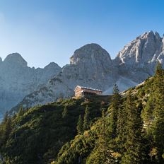
Cosed - Open from 26.05.2025
Ellmau
(0043) 5358 43389
Read more
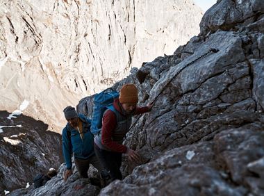
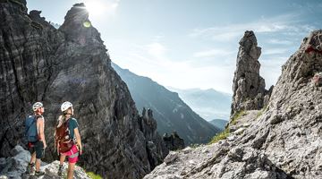
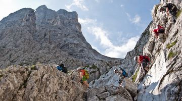
The composition of the trail varies between trail, field of scree and rocky passages with some sections secured by ropes and ladders.
Rucksack, sturdy hiking/mountaineering boots with anti-slip treaded soles, weather-appropriate hiking gear (breathable), a change of clothes, sun protection (sunglasses, sun cream, lip protection, headgear), waterproofs (rain jacket/poncho, pocket umbrella, rucksack protector), cold protection (hat, gloves), sufficient food and drink, hiking poles (height adjustable) if required, first aid kit incl. rescue blanket and bivouac sack, mobile phone with fully charged battery, headlamp, plastic bag for waste, hiking map, route description and information materials (GPX track), ID, insurance card, cash Helmet;
Additions if required: climbing harness and via ferrata set
Additions for overnight stay at mountain hut:
Mountain hut sleeping bag, indoor shoes, toiletries and towel, personal medication, headlamp, Alpine Club ID Card, cash, charger for mobile phone The hiking routes between the huts are often rather long, we recommend taking plenty of food and drink and booking your overnight stays well in advance.
Read more
Fitness
Technical
Experience
01
Jan
02
Feb
03
Mrz
04
Apr
05
May
06
Jun
07
Jul
08
Aug
09
Sep
10
Oct
11
Nov
12
Dec
Cosed - Open from 26.05.2025
Ellmau
(0043) 5358 43389
Gaudeamushütte - Ellmauer Tor - Hintere Goinger Halt - Jubiläumssteig - Gruttenhütte
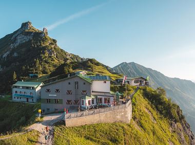
Gaudeamushütte, Going (1,263 m)
Gruttenhütte, Ellmau (1,620 m)
Hiking
Difficult
5:30 h
5,9 km
1010 Elevation gain
Experience impressive low and panoramic views in the unique rocky scenery of the legendary Wild Castle, as this area is known according to legend thanks to its many turrets, peaks, hollows and
Wochenbrunner Alm, Ellmau (1.085 m)
Wochenbrunner Alm, Ellmau (1.085 m)
Hiking
Difficult
3:45 h
6,3 km
630 Elevation gain
Stripsenjochhaus – Eggersteig – Steinerne Rinne – Ellmauer Tor – Jubiläumssteig – Gruttenhütte
Stripsenjochhaus, St. Johann in Tirol (1,577 m)
Gaudeamushütte, Going (1,263 m)
Hiking
Difficult
5:00 h
6,3 km
590 Elevation gain
The panoramic Scheffauer is the last high peak in the west at 2,111 m above sea level.
Hiking starting point Bärnstatt, Scheffau (920 m)
Hiking starting point Bärnstatt, Scheffau (920 m)
Hiking
Difficult
7:00 h
7,9 km
1180 Elevation gain
Approaching from the north, this trail leads through the Steinerne Rinne to the majestic Ellmauer Tor.
Griesner Alm, 988 m
Wochenbrunner Alm, Ellmau (1,085 m)
Hiking
Difficult
5:45 h
8,1 km
1060 Elevation gain
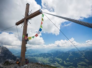
The Hintere Goinger Halt (2,193 m) is considered to be the easiest summit to reach in the Wilder Kaiser.
Hiking starting point Wochenbrunner Alm, Ellmau (1,085 m)
Hiking starting point Wochenbrunner Alm, Ellmau (1,085 m)
Hiking
Difficult
6:30 h
8,9 km
1090 Elevation gain
2025-04-17
9 °C
2025-04-18
10 °C
2025-04-19
17 °C
2025-04-20
20 °C
